
Geographies of Tech Wealth: San Francisco to "Silicon Border"
As the companies, workers and wealth of Silicon Valley creep north into the city of San Francisco, the effects of an industry with a relatively small but highly paid labor force are leading to widespread social unrest. Embodied in the symbolic protests around “Google Buses,” lower-income residents are reacting to tech’s ability to produce so much wealth that is thinly distributed to a small labor force, disinvested from local infrastructure (with private transportation), and funneled to comically useless purposes like the “Google Barges” mysteriously floating in the Bay. However, conversations about tech wealth are often limited to its distribution—with even mainstream economists (as well as The Economist) conceding that, “Facebook will never need more than a few thousand employees.” Clearly, the other side of this is production; even with its relatively small labor force, Facebook can generate billions in wealth and profits. Instagram, the hip photo sharing mobile application, famously had only 13 employees when it sold for $1 billion (that’s around $77 million per employee).
As the companies, workers and wealth of Silicon Valley creep north into the city of San Francisco, the effects of an industry with a relatively small but highly paid labor force are leading to widespread social unrest. Embodied in the symbolic protests around “Google Buses,” lower-income residents are reacting to tech’s ability to produce so much wealth that is thinly distributed to a small labor force, disinvested from local infrastructure (with private transportation), and funneled to comically useless purposes like the “Google Barges” mysteriously floating in the Bay. However, conversations about tech wealth are often limited to its distribution—with even mainstream economists (as well as The Economist) conceding that, “Facebook will never need more than a few thousand employees.” Clearly, the other side of this is production; even with its relatively small labor force, Facebook can generate billions in wealth and profits. Instagram, the hip photo sharing mobile application, famously had only 13 employees when it sold for $1 billion (that’s around $77 million per employee).
What is going on is not only a lack of distribution but an industry’s ability to generate massive profits without the need of a sizable labor force.
San Francisco: Canary of “Wageless Life”
If Detroit is the metropolitan victim of “deindustrialization,” then San Francisco is the victor of the “high-tech economy.” But the centrality of San Francisco in new modes of profitability is experienced in highly unequal ways. While the clashes between long-time residents and the inflow of high-wage “techies” are amplified by the geographic constraints of the San Francisco peninsula, this isn’t just a story about inequality, nor about a lack of housing supply as some cheekily imply.
More than inequality, San Francisco’s unrest stems from a population facing an economy that no longer needs them. Those being evicted from communities of color are not only facing gentrification but also perpetually low-wage labor in an economy that doesn’t need them to produce competitive profits.
Economist and presidential advisor Larry Summers made headlines early this year when he shared his fears of “secular stagnation”--effectively insufficient demand to grow the economy. But as Michigan economic sociologist Greta Krippner has pointed out, this is not a new process, since the rise of “financialization” in the 1980s was already a response to the economic stagnation that began in the 1970s in the U.S. It is in the context of what appears to be the geographic limits on U.S. profits (because of limits of domestic demand, global competition, and over production) that tech provides an avenue for profitability relatively unencumbered by the physical constraints of labor and time.
Working hand in hand with financial speculation, tech is the new industry with the promise of fixing the West’s “New Growth Conundrum.” Chillingly, as the eviction of Bay Area workers foreshadows, a larger economic transition may push a significant part of the domestic labor toward what Yale historian Michael Denning has called “wageless life.” For Denning, these are workers who are a “relatively redundant population,” or to borrow a term from a different context, “populations with no productive function [in the tech economy].” Demand doesn't seem to be the root problem as Summers suggests, as expansions in credit access and the household debt burden have long buttressed wageless demand.
Some might note that high-wage jobs in San Francisco aren’t the only jobs generated by the tech economy. This is true, and following the money of the information economy eventually leads one abroad.
“Silicon Border” and Microwork: The Travels of Tech Wealth
To say that tech and the information economy do not distribute wealth is not to deny that it travels. Of course, venture investments and speculative growth are enabled by flows of global capital. However, equally dynamic is the outsourced production of microchips and the novel “Impact Sourcing” or socially targeted “microwork,” both of which skip the domestic U.S. labor force and seem to be jumping directly to the global South, pre-branded as a poverty solution too!
Tech wealth, in the form of wages, is distributed to somewhat familiar outsourced manufacturing sites. One peculiar example of tech wealth’s international travels is a 4,500-acre free enterprise zone in development not a mile south of the U.S.-Mexico border outside Mexicali. Dubbed “Silicon Border,” this commercial development is managed by the firm Jones Lang LaSalle, whose website prominently features their “2014 World’s Best Outsourcing Advisors” recognition.

Rendering of phase 1 of Silicon Border development, to include a “Science Park” as well as housing and a commercial units. Source: Silicon Border.
Marketing its first of four phases, investors seeks to attract tech industrial work for semiconductor manufacturing, boasting the site’s “Asian manufacturing cost structure in strategic North American location, [Mexican] Government incentives ranging from tax holidays […] free trade zone status […] with USA and 43 additional countries [and] access to reliable electric power, fresh water, waste water treatment and fire suppression systems [in the middle of the Yuma desert].”
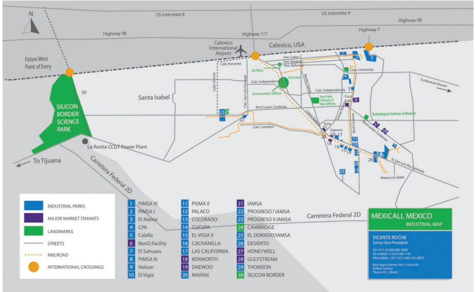
Map produced by Silicon Border developers shows the massive scale of the development when compared to Mexicali, with a population of 700,000. Also, blue boxes represent other, smaller, manufacturing parks all built along international railways and international ports of entry. Source: Silicon Border.
If Silicon Border represents an adaptation of well-known models of securing cheap manufacturing labor abroad, the novel emergence of “microwork” is outsourcing with a social conscious. Microwork initiatives operating globally seek to build a business model around recruiting un- or underemployed workers to perform simple data-based tasks online (think of it as a global information assembly line). While the microwork model is in its infancy, it has already attracted companies like LinkedIn, Google, and Microsoft to this “pay-as-you-go” labor model. Differentiated from outsourcing with the brand “socially targeted sourcing,” this model is promoted as a 21st century solution to poverty that provides not only employment but equips workers with information and communication skills. In the words of the Rockefeller Foundation, social targeted sourcing generates both “financial and social value.” A report commissioned by the Rockefeller Foundation last year estimated that the market for microwork sourcing could rise to $20 billion by 2015.

Diagram mapping the locations of Impact Sourcing Service Providers, most operating in the global South. Source: Rockefeller Foundation.
Perhaps rather than questioning the distribution of tech wealth, we should question the terms of its production and forms of its global movements. The travels of tech wealth are dynamic, but profoundly uneven and unequal. As UC Berkeley MCP student Christina Gossmann shows, there even exists an extensive economy of electronic waste in the rubbish dumps of Kenya—a nation that is working to connect to streams of tech wealth by marketing itself as a potential “Silicon Savannah.” (Also see the Silicon Cape initiative in South Africa).
The eviction of working class families from San Francisco, and rise in inequality, should not be approached as a starting point, but rather as a symptom of a dangerous shift in production to rely heavily on tech wealth. The effects of this are not only domestic, but also unequally global, as this short article has suggested.
To quote artist and journalist Susie Cagle’s brilliant animation of the “class wars” in San Francisco: let’s stop talking about buses, “let’s talk money.”
Luis Flores is a Judith Lee Stronach Fellow at UC Berkeley and runs the Collective History Archive, an interactive oral history platform on debt, the recession, and the “New Economy.” He is a research intern at Causa Justa :: Just Cause. Luis can be reached at jr.luisf@gmail.com

Crowdsourcing 2.0: Why Putting the Slum on a Map is not Enough*
There was a time—not too long ago—when informal settlements the size of small cities were practically invisible. Large and empty beige-gray fields, intercepted by an occasional thin blue line, signifying water, and several thicker, windy white lines that stood for major roads, would pop up on the computer screen when searching for infamous slums such as “Kibera” on Google Maps. The information void stood in stark contrast to the hundreds of thousands of people living in Kibera, ironically tucked away between some of the city’s most valuable and celebrated resources: the Royal Nairobi Golf Club, Ngong Forest and the Nairobi dam.
There was a time—not too long ago—when informal settlements the size of small cities were practically invisible. Large and empty beige-gray fields, intercepted by an occasional thin blue line, signifying water, and several thicker, windy white lines that stood for major roads, would pop up on the computer screen when searching for infamous slums such as “Kibera” on Google Maps. The information void stood in stark contrast to the hundreds of thousands of people living in Kibera, ironically tucked away between some of the city’s most valuable and celebrated resources: the Royal Nairobi Golf Club, Ngong Forest and the Nairobi dam.
Googling Kibera would not reveal much information about the slum, but more significantly, information also lacked within the slum. In the eyes of the government, the slum did not exist or matter and only few stories, usually about gangs and murders with attention-grabbing sensational headlines bordering sinister hilarity, were deemed newsworthy. For relevant and current happenings, residents would therefore consult their social networks: neighbors, friends and family. As the extensive literature on social capital and intelligence has shown, who you know (rather than what you know) contributes enormously to slum dwellers’ complex networks of resilience.
But there are situations when those networks are simply not enough.
One of those situations presented itself on the night of the 30th of December 2007. After Kenya’s general election on the 27th of December, hopes—and polls—were at a peak for the opposition party’s Raila Odinga. But after a three-day delay, incumbent President Mwai Kibaki was unexpectedly pronounced the winner. What exactly happened next and who is to blame continues to be widely debated, but what we do know today is that inflammatory text messages and emails had played a major role in inciting the violence that lasted for two months, resulted in the death of over 1,000 people and the displacement of 350,000. Most of what would later be called “ethnic cleansing” took place in informal settlements, including Kibera, the same areas with the least access to information. Nobody knew whether and when it was safe to step outside the house. After only several days, a small group of programmers released software that would use the same tactics as the perpetrators of violence—SMS and emails—to create an alternative information-sharing platform. Ushahidi, Swahili for “testimony,” mapped reports of crime and violence that could easily be submitted and accessed online or by mobile phone. In both, the global South and its North, crowdsourced crisis-mapping has served as populist tool for asserting political contestation and for checking state violence, in effect producing a “politics of witnessing” at a global scale.

Open Street Map displays various resources in Kibera including hospitals and schools.
Ushahidi shined a spotlight on a long ignored problem: the lack of information on and for informal communities. Although constituting a significant urban demographic in cities of the Global South—and the majority in some, including Nairobi where an estimated 60% of the population lives in slums—slum residents are often ignored in planning processes and budget allocations.
With the goal to change the situation by literally putting Kibera on the map, an international development practitioner and a programmer founded MapKibera in 2009. Through support from local techies who helped train Kibera residents in using OpenStreetMap (OSM) techniques—including GPS surveying and satellite imagery digitizing—Kibera began making a geospatial appearance. In the years to follow, citizen journalism efforts ensued, developing atop the MapKibera information on OSM. The Voice of Kibera community news website and the Kibera News Video Network journalism project indiscriminately cover everyday Kibera, from local fires and elections to a marvelous Bulgakov-esque exploration of Kibera from a dog’s perspective.

Even today, few of Kibera’s resources appear on Google Maps.

The Ushahidi Platform places reports submitted via SMS and email on a map.
MapKibera was the first mapping initiative of its kind. By training local residents in geospatial data collection and visual storytelling through photography and video, MapKibera has significantly contributed to the democratization of media. It also made international news and brought much-needed attention to Kibera. Kibera’s data and founding members traveled the world, presenting their initiative and findings at research and innovation hubs. It was actually at one of those trips to the Massachusetts Institute of Technology Media Lab where I first heard about MapKibera. Without a doubt, MapKibera’s approach and legacy for the Information and Communications Technologies for Development (ICT4D) community cannot be denied.
But is uncovering and making information publicly available enough? The most recent decision of the City County Council of Nairobi not to include informal settlements in the new Master Plan of the city—the first since 1973—indicates that it might not be. With a saturated map served on the OSM silver platter, neither the city nor residents seemed to make much use of it. The City insisted on a dearth of quality information, thus justifying its denial of actively planning for informal residents’ needs and wants in the city’s future development. Residents already knew the locations of basic mapped amenities such as schools, taps and pharmacies in their neighborhoods.
What was needed was information that would allow slum dwellers to assert political agency and claim access to basic needs such as decent housing, water, education and health care—citizen rights that are constitutionally backed since 2010. One example of pro-slum advocates moving towards this target-driven data collection direction is the Spatial Collective, a Mathare-based social enterprise, founded in 2012 by several experienced participatory mappers. Similar to MapKibera, the Spatial Collective benefits from Kenya’s mobile phone penetration rate--more than 77% of Kenyans regularly use a mobile phone--and widely available cheap Internet service to tap into an already existing information system to access local knowledge. They use this data to map slum resources but also their most basic needs. Crime and rape reports, for instance, allow for specific interventions such as installing lamps for safety. But before anything else, the Spatial Collective conducts a needs-assessment and baseline survey to evaluate whether what they do actually makes a difference.
As international development practitioners and technology enthusiasts forge ahead with increasingly popular crowdsourcing initiatives, I recommend the community engage not only in data collection, but in also purpose-driven, accountable data-collection that targets one particular goal at a time. A foreign-founded and partially–funded initiative, the Spatial Collective has drawbacks of its own. But if there is anything we have learned from ICT4D projects by now, it’s that nothing’s perfect.
Christina Gossmann is a Master of City Planning student at UC Berkeley. Before returning to graduate school, she worked as a freelance journalist and researcher in cities of the Global South. Email her at christinagossmann@gmail.com and follow her at @chrisgossmann.
*This story originally appeared, in a slightly different version, on Barefoot Lawyers International and The Con.
Fear and the Urban Form
“I don’t mind the American soldiers on our streets. If I could talk to them I’d ask: Why are you so afraid of us? Why do you fear us so much?”
So answered my Afghan friend, when I asked him how he felt about the American troops parading the streets of Kabul. I expected him to be appalled by the invasion on his privacy, or sovereignty. But what appalled him most was their fear, and how it seeped into his everyday life. When he looked at them too long, they pulled out their gun, he said. I thought the high walls and barbed wires of Kabul’s new architecture conveyed the same message.

Gated community in Sao Paulo, Brazil. Source: Tuca Vieira.
“I don’t mind the American soldiers on our streets. If I could talk to them I’d ask: Why are you so afraid of us? Why do you fear us so much?”
So answered my Afghan friend, when I asked him how he felt about the American troops parading the streets of Kabul. I expected him to be appalled by the invasion on his privacy, or sovereignty. But what appalled him most was their fear, and how it seeped into his everyday life. When he looked at them too long, they pulled out their gun, he said. I thought the high walls and barbed wires of Kabul’s new architecture conveyed the same message.
Anthropologist Teresa Caldeira, in her book City of Walls: Crime, Segregation and Citizenship in Sao Paulo, analyzes the escalation of crime in Sao Paulo since mid-1980s that generated widespread fear. This led to “new strategies of protection and reaction in the city, of which the building of walls is the most emblematic. Both symbolically and materially, these strategies operate by marking differences, imposing partitions and distances, building walls, multiplying rules of avoidance and exclusion, and restricting movement,” she writes.
Fear is an emotion induced by a perceived threat, and the perception of threat is dependent on many things – including, but not limited to, gender, age, sex, race, neighborhood cohesion, confidence in police, personal experience of victimization, levels of local incivility and financial conditions. In the previous examples fear is a result of the loss of power in structurally unequal relationships with a collective “other”, whether it is the U.S. military that elicits a fear of violent contestation or the wealthy elite in Sao Paulo. In both, the nature of the observer and nature of the observed environment influence one’s perception of threat. But the relationship between fear and our built environment is for me, most peculiar. Probably because it is hard to tell whether form follows fear or fear follows form.
Can we Design away Fear?

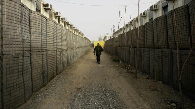
In Afghanistan, "HESCO Barriers" line corridors protected by sand barriers thick enough to withstand the impact of a car bomb. Source: NPR.
If fear indeed follows form, I am tempted to ask: Can we design away fear? There has been no dearth of attempts made in the past to do this.
After the Industrial Revolution, modern architecture sought to assuage the fear generated by rapid industrialization and urban problems of ‘disorder’ – giving birth to modernism. The profession of planning meanwhile diverged from its initial agenda to become primarily curative rather than preventive or formative. Postmodern urbanism sought to improve upon the shortcoming of modernism and to respond to the peculiar nature of fear that it in part caused. But it ended up falling in the same traps (see Nan Ellin's 2007 Architecture of Fear).
Architect Nan Ellin says in Architecture of Fear, “Contemporary insecurity has elicited a reassertion of cultural diversity, nostalgia for an idealized past, an infatuation with mass imagery, flights into fantasy worlds, a marked privatism, and a spiritual turn. In urban design, these tendencies are primarily manifest as historicisms, regionalisms, and allusions to mass culture.”
The contemporary focus on crime and safety in relation to the built environment began with the American-Canadian journalist, author and activist Jane Jacobs in the 1960s. To her, a safe city was the traditional city with streets and blocks, diversity, functional mix, concentration and buildings of different age. Her observations were astute but without systematic empirical evidence.
In 1972, architect Oscar Newman developed a more targeted response to safety through design, with the concept of Defensible Space. His answer to the problem was introducing a more graduated territoriality through the creation of semi-public and semi-private spaces – and to some degree, by putting up fences. His work was evidence-based with, for instance, detailed spatial descriptions and statistics.
But can crime really be prevented through environmental design? It is a question open to debate. Any effort to understand the relationship between fear and the built form based purely on empirical evidence is futile, because actual crime figures do not present the whole picture. Let me illustrate with an example.
Take a neighborhood with very sophisticated surveillance, security systems and 24-hour guards. Measures that make impossible for one to bat an eyelid without someone cooped up in a surveillance room knowing about it. Actual crime rates are reduced to a minimum here. But is this an ideal living environment? Are we not bargaining our sense of security for our sense of freedom? Are we not compromising our ‘right to the city’?
Secure but Segregated
The latest and perhaps more extreme reaction to the problem of crime and fear of crime in cities are enclosed housing developments, often called gated communities. A gated community is a housing development on private roads closed to general traffic by a gate across the primary access. The development may be surrounded by fences, walls or other natural barriers that further limit public access. These housing developments have become popular in some severely crime-ridden developing countries, such as South Africa and Brazil but to a large degree are also found in the USA, where more than seven million households (about 6% of the national total) are in developments behind walls and fences.
Developments of this kind create spaces that contradict the ideals of openness, heterogeneity, accessibility and equality. This is fairly evident in the city of Los Angeles. Like in many other global cities, as the economic disparity deepened over time so did the lines of segregation. Most of L.A.’s public life takes place in segregated, specialized and enclosed environments like malls, gated communities, entertainment centers and theme parks. Many of these changes in urban environment are furthering separation between social groups that are increasingly confined to homogenous enclaves. The consequences of this new ‘separateness’ can be drastic. Defensible architecture and planning may end up promoting the same conflict that it was intended to prevent.
Freedom from Fear

The city of Oakland recently received $7 million from the federal government initially intended to deter terror attacks at the port of Oakland. Instead, these funds are being used by a Oakland police initiative that will collect and analyze surveillance data. Source: Globalresearch.org
Different cultures have different ways of fearing. The meaning a society attaches to the fear of God or the fear of hell is very different from the fear of pollution or the fear of cancer. As Frank Furedi explained in “Culture of Fear”, we associate fear with a clearly formulated threat and today we represent the act of fearing itself as a threat.
In that sense we are all victims, even if we have not personally experienced an act of crime, since we are all aware of it, and live in fear of it. This is a fear we are reminded of every day in media, daily conversations and sub-consciously, through our environment. This fear infringes on our everyday behavior, activities, sense of security but also freedom.
As architects and designers, we need to view the issues of safety and fear from a new lens. Maybe crime prevention alone is not a solution. An alternative to ‘gatedness’, a neighborhood that is secure but not segregated, needs to be imagined, if we hope to finally reach the root of the problem.
Tanvi Maheshwari is a Master of Urban Design student at UC Berkeley. She is currently pursuing her thesis on the subject of fear and its relationship to urban form in the Indian context.
She can be reached at
.
The Significance of Community in Modern Planning Theory
David Chavis’ 1990 article, “Sense of Community in the Urban Environment: A Catalyst for Participation and Community Development," highlights the effects that perception of environment, social networks, and how residents’ sentiments about their communities can further influence the behaviors and perspectives of others. The article further emphasizes the importance of citizen participation in community organizing and explains why it has been regarded as key to improving the quality of the physical environment, enhancing services, preventing crime, and improving social conditions.

Reflections on: "Sense of Community in the Urban Environment: A Catalyst for Participation and Community Development," by David M. Chavis
David Chavis’ 1990 article, “Sense of Community in the Urban Environment: A Catalyst for Participation and Community Development," highlights the effects that perception of environment, social networks, and how residents’ sentiments about their communities can further influence the behaviors and perspectives of others. The article further emphasizes the importance of citizen participation in community organizing and explains why it has been regarded as key to improving the quality of the physical environment, enhancing services, preventing crime, and improving social conditions.
I view the institution of a locally-driven planning process as being essential to the establishment of a general sense of community. The maintenance and enlargement of self-sufficient, self-governing bodies (community organizations), further signify the additional role that empowerment has in local development. According to Chavis, a working definition of the term “sense of community”, suggests local processes of development that create opportunities for membership, influence, mutual needs to be met, and shared emotional ties and support. Essentially, a sense of community points to the strength and shared benefits of social capital. The more invested we are in community, the more power and ownership we feel we have in the communal environment. It is through this process that a sense of community contributes to individual thought for collective development.
I find it immensely intriguing, that when we compare communities that seem to be thriving, both socially and politically, to low-income communities, plagued with the accompanying concerns of crime, disinvestment and unemployment concentrated in a single area of poverty, one tends to wonder if there is a specific criterion of that qualifies it. Trends in both these specific communal types seem to possess a constant, regardless of country, city, location, ethnic makeup, etc. However one might evaluate the success of a community, the residents of perceivably well to do communities possess a notably stronger sense of community, than do residents of less socio-politically affluent communities. This sense of community therefore compels residents to develop and maintain social networks, in addition to in social capital. This investment in social capital is yet again, another product of that sense of community. A sense of community can have a great influence on one’s desire to control or contribute to the environment, often helping to address problematic concerns that may be regarded as problematic. For instance, I view the formulation of this ‘sense of community’ as being instrumental to the effectiveness of the Occupy Movement. A collective effort, with one voice, and a common goal. The control or occupying of space is but a means by which to establish an improvised locale for a “quartered” community. The resolve to maintain these claimed spaces was clear in the emergence of riotous protest as Occupiers clashed with law enforcement (in their attempts to divide the urban community, before conquering the social community). Another example of this can be seen in 1957’s, Little Rock’s Nine during the integration of Central High School. The local community viewed academic integration as problematic. When the National Guard intervened, (an additional group of “outsiders”) to enforce the law, the resistance became unpredictably explosive.
Although the concepts of Social Capital and Networks could quite easily take us into totally separate discussion altogether, in this context, I view social capital and social networks as being interdependent. Social capital deals with the product, the talent, skill or unique ability one contributes to the greater community with which he holds membership. Social networking speaks to the ways in which members of that community bargain to benefit one from another by the utilization of this collection of gifts and talents. All these are major players in the establishment and maintenance of a sense of community.
Apart from physical features, one of the key distinctions between these community types is the length to which residents will collectively go to protect “their” society. Examples of this are seen in high-price residential communities like Pleasanton, CA. for example. A highly expensive neighborhood where the rent you pay for a 2-3 bedroom condo, could match that of the cost of a home mortgage in parts of a city like Oakland. The economic support or disinvestment in local businesses is another way communities might protect their neighborhood. According to Chavis, perceived control relates to the beliefs an individual has about the relationship between actions (behavior) and outcomes.
The protection of a society further suggests that there are boundaries involved. These boundaries could be physical barriers such as gated communities, rivers, railroad tracks; or even socioeconomic barriers such as highly priced property, educational requirements, and other forms of exclusive criteria. These boundaries form due to society’s perception of “the other”. Therefore, in order to retain some sense of emotional security—to live without fears—communities tend to form boundaries in which to maintain, occupy, and repel others from entering.
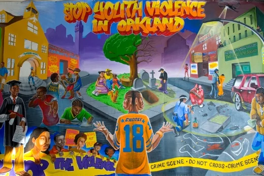
Working to help establish a sense of community in modern planning today should be held as a vitally important aspect of the planning process. The mural below depicts this perfectly. It was designed by a youth empowerment program in Oakland CA, Youth UpRising. The youth of Castlemont were included directly in the planning process. This mural is a reflection of what the young people view as the areas of concern in their community and what they actually want their community to evolve into. Considering the impact that community and developmental endeavors can have on the outcomes of specific regions, in order to further eliminate the formation and spreading of concentrated despair, community building must become a more integral part of the planning process.
Julian Collins is interested in topics of housing, community and economic development. He received his Bachelors from the University of Illinois, Chicago in Urban and Public Affairs and is now pursuing a Masters at the UC Berkeley in City and Regional Planning.

Bogotá’s Bucolic Exodus: Aspirations of a Rural Life or Suburban Sprawl?
Yearning for a rural lifestyle is a legitimate desire for all city dwellers. It is more than understandable to think about a nicer place if you can afford it, considering that “nicer” often means more greenery and nature. Nevertheless, countryside living is not only an aspiration for people in Bogotá who are planning a systematic exodus from the city’s current sense of collapse, but also for displaced rural people who try to make a living in the city. Sometimes there is a situation of urban dwellers colonizing farmers’ land, or the current national social illness of forced displacement.

Illustration of the migration pattern. Source: Author
Yearning for a rural lifestyle is a legitimate desire for all city dwellers. It is more than understandable to think about a nicer place if you can afford it, considering that “nicer” often means more greenery and nature. Nevertheless, countryside living is not only an aspiration for people in Bogotá who are planning a systematic exodus from the city’s current sense of collapse, but also for displaced rural people who try to make a living in the city. Sometimes there is a situation of urban dwellers colonizing farmers’ land, or the current national social illness of forced displacement.
In Bogotá, like in many cities, transportation deficiency, generalized security concerns in many areas and the increasing cost of living are negatively influencing the everyday experience of its citizens. It is therefore perfectly reasonable to consider moving to a place where the pace of daily activities is slower, groceries are cheaper and air is cleaner. Large cities and capitals offer job opportunities, cultural exchange and superior levels of health and education that do not exist in rural areas. In this sense, despite its utilitarian purposes, the city has become increasingly unaffordable, insecure and threatening, especially for rural migrants.
La Calera, for example, is one of the “rural” paradises desired by high-income people in Bogota, and utterly pursued as a pot of gold by real estate developers. However, this place is one of the city’s principal natural reservoirs, in terms of water supply and green areas. If Bogotans continue running away from the city to settle permanently in a place that is geographically guaranteeing our city subsistence, we are threatening urban collective survival. And on the other hand, people that are actually living in places like this cannot migrate to the city with no credit history or any urban expertise, because life in the Colombian countryside is just too different.
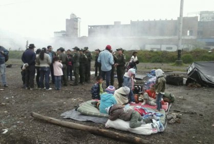
Displaced communities in Downtown Bogota. Source: RCN La Radio
How do we interpret the trend of urban dwellers dreaming of the countryside and rural dwellers being forced to move to cities? Will we see Colombian cities filled with “for rent” signs and rural parcels abandoned or used for suburban homes, violating not yet written environmental policies? For a poor peasant for example, starting from scratch in a city like Bogota can lead to a sense of not belonging. Working in minimum wage jobs, whether in the formal or informal sector sometimes results in resignation, resentment and even violence, as a consequence of being forced to obey a system that apparently has not been designed for equality. In this sense, the question would be if this two-way rural-urban migration corridor is leading to any collective improvement for any of the participants involved.
Maybe visualizing these possible outcomes of current mobility trends can help us achieve a balance. If there is no urban expansion, inner city land values will be increasingly raised to the point of absolute unaffordability, but at the same time, suburban sprawl has a huge impact on ecology and demand for infrastructure that is equally destructive. On one hand, real estate speculation of suburban developments is supplying housing demand for high-income households only. And on the other hand, barely legal urbanization in risky areas of the city is only supplying housing lots for many of the low-income people that are coming into the city as cheap labor. This way, both the high-end suburban housing and the informal inner city housing seem like extreme responses to these recent moving trends.

La Calera suburban housing. Source: SkyscraperCity.com
Maybe it is about public policies that ensure affordable housing for all citizens, regardless of their incomes. Or it might be about adaptability. Bogotá could (and should be) more inclusive for migrants by providing jobs and housing opportunities, whether they come from the countryside, from other cities, and even from other countries. Also, maybe the city can offer better conditions so its actual inhabitants don’t feel the urge to escape. Probably cities can be understood beyond the utilitarian aspects of just being destinations for concentrated job opportunities. In this manner, the urban experience could be positive for all. What if we bring more high quality services to the countryside and bring more environmental qualities to our cities? This way we might not be forced to endure this polarization of individual needs that are turning migration processes in Colombia into an evident symptom of inequality.
I envision a more inclusive Bogota indeed. And this probably demands a deeper understanding of the rural-urban mutual dependency, for both in citizens and policy makers. In this sense, some of the government’s efforts providing affordable housing for rural migrants are strategies of more equitable policies that somehow still seem insufficient. This raises the question about the causes of these inequity indicators in Colombia’s capital. Will affordable housing ever be enough and what will happen when the city runs out of land? Is increasing new housing supply the solution for a larger scale political conflict that is massively displacing people from our most forgotten rural areas? And on the other hand, how can policies also regulate this recent trend of suburban sprawl that is also taking over the countryside? Maybe this recent circular migration pattern is an opportunity to visualize how a city embodies the illnesses of a country. But also, an invitation to ask ourselves: Is moving the solution? Where will these exoduses lead us to?
Maria Luisa Vela is a first year graduate student at UC Berkeley, pursuing a Masters in Urban Design. She is a practicing architect from Bogota, Colombia and is currently interested in the relationships between public space and housing typologies for designing better neighborhoods in Latin American cities. She can be reached at marialuisavela@gmail.com
Redefining Shrinking Cities
Shrinking cities have been the subject of much conversation in recent years. With Detroit filing for bankruptcy protection and the growing concern about aging cities in Europe, the discussion is gathering ever more momentum. In a climate of hasty blanket statements and one-size-fits-all solutions, Aksel Olsen takes a step back to critically examine the phenomenon of shrinking cities, in order to find real, practical solutions.
A significant number of cities and regions across the US and Eastern Europe currently face population decline, economic contraction, or both. The ‘greying of Europe,’ where nearly a third of the population will be 65 or over by 2060, is increasing pressure on social services, urban infrastructure, and the labor supply.
In Volume 26 of the Berkeley Planning Journal, Ph.D. student Aksel Olsen’s ‘Shrinking Cities – Fuzzy concept or useful framework?’ enters the debate on urban decline. In this post, Masters of Urban Design student Tanvi Maheshwari explains why practitioners should look beyond simplified versions of the shrinking cities phenomenon.
Shrinking cities have been the subject of much conversation in recent years. With Detroit filing for bankruptcy protection and the growing concern about aging cities in Europe, the discussion is gathering ever more momentum. In a climate of hasty blanket statements and one-size-fits-all solutions, Aksel Olsen takes a step back to critically examine the phenomenon of shrinking cities, in order to find real, practical solutions.
A significant number of cities and regions across the US and Eastern Europe currently face population decline, economic contraction, or both. The ‘greying of Europe,’ where nearly a third of the population will be 65 or over by 2060, is increasing pressure on social services, urban infrastructure, and the labor supply. The trend is raising new concerns for planning and design, such as how to create different types of mobility structures for the elderly population. For Eastern European cities, the out-migration of young workers seeking better employment opportunities has made the equation even more difficult. As tax bases shrink, planners and politicians in both the US and the EU will need to attract and retain a younger workforce, in part by reforming immigration policy, and make the urban environment accessible for the elderly.

Percentage of Population over 65 in Europe. Source: http://en.wikipedia.org/wiki/File:Europe_population_over_65.png.
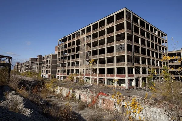
Shrinkage is not a new phenomenon. During the post-war years in the US, the middle classes fled in hordes from dense city centers to rapidly developing suburbs, aspiring for space and racial homogeneity, thus hollowing out the city cores. In the present context, however, intra-city shrinkage is not planners’ primary concern. In fact, many American suburbs are shrinking as well. Cities in the Rust Belt grew in an era when large-scale manufacturing required large amounts of labor. With much of their traditional labor force no longer as in demand in the modern economy, many Rust Belt cities such as Detroit face population and economic decline. Leaders in these cities have attempted different strategies, with varying success, to reinvent their image and their economy around creative industries, a manufacturing renaissance, or the service sector.

Decline of Detroit. Source: http://en.wikipedia.org/wiki/File:Abandoned_Packard_Automobile_Factory_Detroit_200.jpg.
But shrinkage today is a complex phenomenon, not limited just to the Rust Belt. It is afflicting much more heterogeneous regions, including those around the Californian cities of Fresno, San Francisco, and San Jose. It should be noted that the time period when shrinkage was observed in these cities mostly coincides with the 2001–2002 recession. During this time, San Jose did indeed lose population at a rate of three per thousand or so for a two-year period. However, while the rate of population decline was at about three per thousand in 2002 and 2003, the number of occupied housing units appears to have increased over the same period at a rate of seven per thousand. This may mean that the shrinkage observed is San Jose may just a change is demographics, like change in size of household. It may not be valid to call San Jose a shrinking city, as shrinkage may be just a temporary result of a city in flux.
Aksel Olsen’s paper argues that shrinkages in Eastern European cities, the Rust Belt in the US, and in the Californian so-called “Sun-Belt” cities are not comparable. In fact, bundling them together creates a fuzzy definition, watering it down to the point where it is no longer useful to describe the vastly different trajectories of urban evolution. The scholarly definition of shrinking cities is ‘a densely populated urban area with a minimum population of 10,000 residents that has faced populationlosses for more than two years and is undergoing economic transformations with some symptoms of a structural crisis.’ A tighter definition, taking into account specific contexts, would be more helpful to planners.
The typical definition of a “shrinking city” is flawed in two key ways. First, it fails to distinguish shrinkage due to an aging population from shrinkage due to shifting industries. Each requires different policy strategies. A lower fertility rate may be a long-term problem, but in the short term, the migration balance matters more because it has a greater effect on the economically active population. Further, a thriving city center may still experience population growth despite industries moving out. The San Francisco Bay Area during the Dot Com Crisis of the years 2000–04 would be an example of population growth and a changing job base. This distinguishes a Detroit from a San Francisco.
Second, the typical definition of shrinking cities is too shortsighted. Planners should look at the long term. Olsen equates short-term forecasts of “shrinkage” to comparing ‘weather’ with ‘climate’, one representing short-term changes and the other, long-term structural changes.
A city with a rapidly growing economy might shrink deliberately, to create a better quality of life for a smaller population, or may going through a phase of transition. In the 1980s, Pittsburg began to focus on high-end retail. Pittsburgh seems to be in the midst of a transition to an entertainment economy, even as the city continues to lose population, again underlining the complex patchwork of prosperity and decline, here at the city scale. Despite half a century of population loss due to industrial decline, Pittsburgh is, if not thriving, certainly outperforming both the Rust Belt and the nation as a whole. Its unemployment rate of 7.8% is well below the national average.

Pittsburgh Skyline. Source: http://commons.wikimedia.org/wiki/File:Pittsburgh_Skyline.JPG.
Should shrinking cities then be defined as simply a state of being, defined on the basis of population loss or job loss? Or should a deeper investigation be made into its underlying causes? The latter is essential, if the city has to devise policy directions to deal with the situation. Growth and decline are a part of the natural cycle of a city’s life. If short-term fluctuations are assumed to reflect broader trends, urban policy-makers will fail to identify the true causes of shrinking cities resulting in uninformed policy decisions and a trivialization of the issue. Planners should think about ways to preserve affordable housing to prevent gentrification when there is rapid growth occurring.
Olsen’s paper left me convinced that contextual analysis, that is, a qualitative typology to define shrinking cities instead of a quantitative one, would lead to more useful observations. These can serve as a comparative framework for analyzing similar cities worldwide. A qualitative approach leads to more relatable comparisons between shrinking cities of erstwhile East Germany and the Rust Belt in the US, instead of the Sun Belt.
I would argue for uncoupling ‘prosperity’ from ‘ever increasing growth’, and urge cities to plan for ‘smart decline.’ Shrinkage may not always be a bad thing. In the words of Aristotle: “A great city should not be confounded with a populous city.”
Tanvi Maheshwari is a Master of Urban Design student at UC Berkeley. She is interested in urbanism of the global south and segregation in the public realm. She can be reached at tanvi@berkeley.edu.

The Small Indiscretions Of Lagos
An article in South Africa's Mail & Guardian boldly declares: “Nigeria's property boom is only for the brave.” Lagos is one of the continent's fastest urbanizing, rapidly expanding, bursting at the seams, oil-financed megacities. In this frenzy for investment, migration, and growth, Africa's amorphous--and apparently brave--middle class persists in jockeying for space in an exponential metropolis. So, too, does international real estate capital. Making space for its clean landing in Lagos demands at times the material expansion of the city, dredging the lagoon to build the new high-end enclaves of urban investment. And while real-estate interests demand firm ground, Lagos' slums barely stay afloat.
Source: http://theglobenewspaper.blogspot.com/2013/09/how-to-ensure-transparency-in-land-deals.html .
An article in South Africa's Mail & Guardian boldly declares: “Nigeria's property boom is only for the brave.” Lagos is one of the continent's fastest urbanizing, rapidly expanding, bursting at the seams, oil-financed megacities. In this frenzy for investment, migration, and growth, Africa's amorphous--and apparently brave--middle class persists in jockeying for space in an exponential metropolis. So, too, does international real estate capital. Making space for its clean landing in Lagos demands at times the material expansion of the city, dredging the lagoon to build the new high-end enclaves of urban investment. And while real-estate interests demand firm ground, Lagos' slums barely stay afloat.
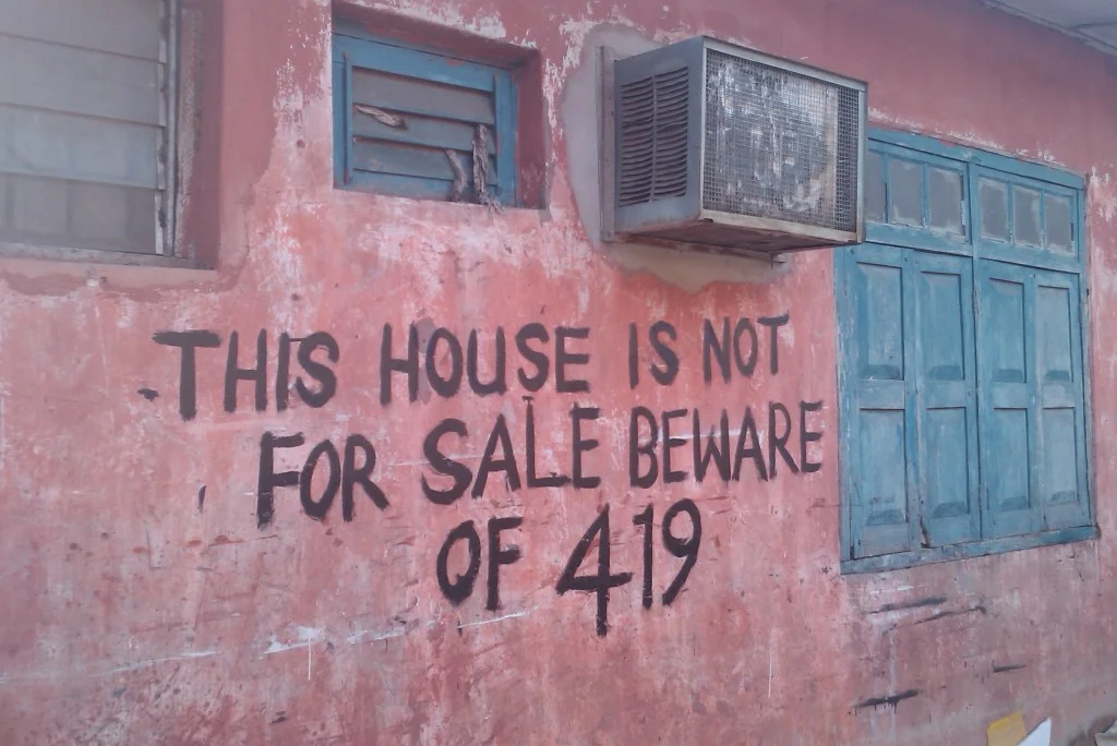
But space isn't enough. Congestion requires bravery, a necessary tool for navigating the uncertainty of Lagos’ land markets. To prove one’s bravery, the Mail & Guardian proposes a trial of agility: buy property in Lagos. The city's unhinged and impenetrable property record-keeping regime is reminiscent of public land holdings in North America's disorganized land management systems. Assuming they exist, Lagos’ land records are dispersed across multiple bureaucratic bodies and determining the validity of property ownershiprequires a laborious dive into the catacombs of municipal administration. This prompts awkward questions to your Lagos-based real estate agent: Do you even know who owns this building? This bureaucratic wall demands a similar fix to the ever-present problematic of African corruption: the transparency of land tenure. Instead, the 419 property scam abounds, where brokers successfully sell homes and land they do not own to unwitting buyers. A meticulous hustle that requires a fast pitch and often a forged title, the 419 scam is the illusion of trust, the predatory imitation of formality, and a stereotype of Nigerian technique.
But in the rush of urban life, trust is more expedient than validity. There is little time to find out what is real and trust will have to suffice. For those Nigerians unwilling to bet against uncertainty, the 419 has spawned a beleaguered, self-proclaimed lawyer who posts swindle avoidance advice on Nairaland. In 2010, with more 419-avoidance work than he could come to terms with, our lawyer falls apart: "I thought I knew every trick in the book and how to deal with them but they kept on coming at me like a heavy downpour and I couldn’t catch my breath in most situations. In fact it was so bad that I almost gave up handling property matters and questioned my competence in some instances." Lagos is underwater. This small public vestige of (fee-for-service) help can hardly keep his own head above water, let alone your property deals.
Our beaten-down west African private investigator shares his encounters with the 419 in a series of extravagantly informative vignettes replete with dodgy surveyors and GPS systems seemingly always on the fritz; subtle discrepancies in forged family deeds crafted by an insider mole; an un-earthing of the hidden remains of "buyers beware: not for sale" sign in the last minutes before a land-deal. Oh, the crushing suspense! Avoiding ruin requires constant vigilance and flexibility, something this intrepid lawyer (barely) manages to post publicly online. He is the public defender of proper land circulations, plugging the holes through which the 419 siphons off common capital.
Is this Nigeria? In Chimamanda Adichie's novel Americanah, the devastatingly insightful protagonist, Ifemelu, struggles with her identity as a been-to (that select group of young returnee Lagosians hungry to compare the city to elsewhere). Ifemelu writes in her blog, The Small Redemptions of Lagos: "Lagos has never been, will never be, and has never aspired to be like New York, or anywhere else for that matter... [Nigeria] is a nation of people who eat beef and chicken and cow skin and intestines and dried fish in a single bowl of soup, and it is called assorted, and so get over yourselves and realize that the way of life here is just that, assorted" (p. 421).
Met with the disparaging comments about North American blacks from fellow Nigerians, Ifemelu struggles to speak for either place:
Her Nigerian co-worker--a huge fan of the American show Cops--asks, "Why is it only black people that are criminals over there?"
To which Ifemelu, after a protracted silence, slowly responds: "It's like saying every Nigerian is a 419."
An amused retort: "But it is true, all of us have small 419 in our blood!"
Ifemelu gives up arguing with her co-worker, quits her job, and begins her new blog, a lyrical accounting of Lagos’ cityness emblazoned with a large, abandoned colonial mansion as its masthead. (I imagine this mansion with a hand-painted sign boldly inscribed on its facade: NOT FOR SALE). It is her return to Nigeria. It is not a relocation with an eye to elsewhere, but a feeling that "she had, finally, spun herself fully into being". Nearly unbundled by the constant re-education of this month's latest scam strategy, our own intrepid protagonist--the Nairaland Lawyer--persists, posts, and spins together his own income-generating position from the deluge of pleas for help from his online readers.
As the Mail & Guardian recounts, a solution to this exasperation and this bravery-in-the-face-of-uncertainty is the transparency of land laws. Routinization, organization, reliability: undifferentiated goods. Here, the security of tenure smooths out life for the West African middle class, opening new vistas of re-assuring liquidity for formal housing finance--no more borrowing from family, as you can finally borrow from the bank. Here, the security of tenure smooths out business for the global financial class, opening new landscapes of liquidity free from burdensome local uncertainties--no more worrying if your debtors will repay or if the deed you bought is legally attached to land.
Lagos is churning uncertainty into routine, but the city’s poorest residents are increasingly displaced. Nigerian architect Kunlé Adeyemi, alongside place-based community organizations, designed and built the first floating school in Lagos’ lagoon slum, Makoko. Prince Adesegun Oniru, the Commissioner for Waterfront and Infrastructure Development in Lagos State, responded by declaring the school illegal. He states, “The floating school has been illegal since inception…The simple answer to the floating school is that it is an illegal structure and it shouldn’t be there.” Since mid-2012, the government has been systematically demolishing Makoko, dispossessing the poor of their already tenuous claims to water-bound residence.
Lagos has a routine. It is a social infrastructure spun together by a series of “tentative cooperations based on trust.” These are the everyday negotiations of making life work in the exponential metropolis. The swindle is one part of this infrastructure, but does not represent it. The swindle violates it. If the formal routine--the new visibilities, formalities, and transparencies--succeeds in making urban life more durable for the African middle class, it will open the doors of institutional trust at the same time it drowns Makoko’s schools. It will stop all this needless spinning together, making work, and siphoning off. It will save Lagos from its own scam, but narrow the city’s robust assortment of life in the process.
Chris Mizes is a PhD student in City and Regional Planning at UCBerkeley. He is interested in landscape politics, infrastructure, land tenure, and African urbanisms. He blogs about his research interests at spacewithinlines and can be reached at mizes@berkeley.edu.

St. Louis’ Ballpark Village: Subsidizing the Status Quo
Some see the rising steel structures in downtown St. Louis as milestones in a long-awaited project, others as an unwelcome reminder: as construction on the Cardinals’ Ballpark Village becomes more visible, controversy surrounding the $650 million development has also grown.
Ballpark Village has been envisioned as a new downtown destination for over a decade, but like thousands of other developments nationwide, remained just a vision until earlier this year due to the recession. The 2007 plan included high-rise condominiums, bars, shops, restaurants, plus the introduction of a street grid intended to integrate the project into the surrounding downtown neighborhood. The current construction, however, will include none of the mixed-use features, and replaces much of the planned development with a bemoaned surface parking lot.
But is a Midwestern parking lot worth discussing within a larger planning context? The success of American cities in the 21st century has to a large extent come from the reclamation of - and reinvestment in - urban identities. Ballpark Village, by contrast, neglects downtown St. Louis’s urban character, which is increasingly dense, walkable, and home to a wealth of independent shops and restaurants. In ignoring the city’s resurgent urbanity, developers have also shown a disregard for St. Louis’s historical position as a major American metropolis, missing out on an unequivocal opportunity to showcase a nationally meaningful urban identity.
St. Louis, Missouri, is a city that has undergone multiple transformations, which map closely onto broader national trends. It has morphed from Mississippi trading post to peripheral Rust Belt manufacturing center, to glimmering site of the magnificent 1904 World’s Fair, to metropolis known for blight rather than bustle. In the last half-century, St. Louis became a laboratory for misguided urban renewal attempts that coincided with the construction of one of the nation’s most impressive monuments to modernism, the Arch. St. Louis’s urban fabric and population have also continuously been shaped by federal housing policy: the massive ambition of the Arch, appearing just a few years after the ill-fated construction of Pruitt-Igoe, one of the country’s most infamous housing projects, attest to the city’s synchronicity with nationwide sentiments and policy currents. Appropriately, Al Jazeera opinion writer Sarah Kendzior writes that in the 21st century, St. Louis has become “the gateway and memorial of the American dream.”

1965 construction of the St. Louis Arch, roughly 10 years after the completion of Pruitt-Igoe. Source: National Park Service, Jefferson National Expansion Memorial.
Today, St. Louis’ identity reflects each of these national epochs, but amajor piece of the city’s character comes not from its industrial history, housing projects, or architectural talking points. Instead, it draws from America’s favorite pastime—baseball. St. Louis’ relationship with its baseball team, like many American cities', is a historic relationship closely tied to the city’s identity and a source of pride. The Cardinals’ Busch Stadium, located centrally in a downtown area, is a boon to the city. Frequent ballgames draw spirited crowds, who often venture outside the ballpark to downtown restaurants and fill area bars following both raucous wins and disappointing losses.
Rebuilt in 2006, Busch Stadium was unusual in that it was financed predominantly by the Cardinals’ private funds (nearly 90%). The city did, however,cover a local admissions tax on tickets, as well as assist with initial public infrastructure costs. There’s no doubt that the construction of the new stadium in 2006 was a worthwhile investment with a sizable return for the city. But does this justify the team’s newest endeavor?
The reality of the project today, after six years of delay and economic uncertainty, is far less ambitious than that initially proposed. The development’s first phase is now slated to offer a baseball history museum, a “Cardinals Nation” restaurant, a cowboy bar, and a two-story “Budweiser Brew House.”

An early plan for the development shows the introduction of six city blocks. Source: nextSTL
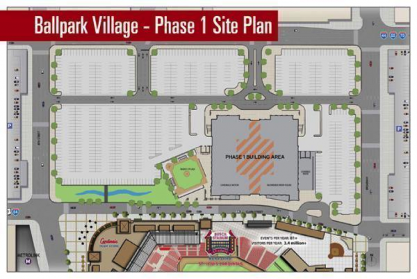
An early 2013 plan also shows the diminished street grid and the replacement of housing and retail with surface parking. Source: nextSTL
Critics, including leading urban blog voice Alex Ihnen of NextSTL, as well as a few local aldermen, are particularly incensed by a400-plus-space parking lot. Developers promise the lot holds potential for additional uses in the next phases of development, but there are currently no concrete plans for the space. Alderman Scott Ogilvie told the St. Louis Riverfront Times in August that "It is literally the exact opposite of the kind of development that creates better urban environments,” arguing that a taxpayer subsidy should go to development that has more to offer the city.
Ogilvie’s argument has merit. A much-cited analysis published by the Brookings Institution studied the economic effects of sports and found little significant gain when public funds are invested in sports teams and stadiums.The authors found that rather than attracting additional spending, new sports facilities simply “realign” purchases that fans might’ve made elsewhere. That is, it’s unlikely that they’ll bring additional revenue downtown to anyone but the Cardinals’ owners and stakeholders.
Private interests vested in Ballpark Village’s construction will profit the easy way: with no obligation to deliver progress or innovation to downtown St. Louis. Ballpark Village, which city aldermen voted to give TIF (tax-increment financing) benefits, is receiving substantial public funds. When applied discriminately, TIF can be a powerful tool for revitalizing neighborhoods and drawing businesses and people to struggling areas. But without a mixed-use district that includes housing options as well as restaurants and bars, the project won’t bring anything new to downtown St. Louis. What does this mean for the city that represents the “gateway and memorial of the American Dream”? Ballpark Village is an unprecedented opportunity for the Cardinals and the City toleverage St. Louis’s love of baseball and create a walkable, mixed-use new stadium area. This will not only draw crowds from the suburbs on game days, but may convince St. Louisans of the vitality and viability of actually living downtown.
More than that, though, Baseball Village prompts questions regarding urban identity and development that are playing out not just on the local scale, but nationally as well. Foremost--how is urban identity constructed? An excellent video on Buffalo, New York’s history as “America’s Best Designed City” showers attention on the city’s points of planning pride. Cincinnati has just begun construction on the downtown Cincinnati Streetcar. The Marcy-Holmes neighborhood in Minneapolis launched its own participatory community planning website over the summer, where residents can suggest and vote on riverfront improvements and bike lane additions, among other things.
Instead of capitalizing on urban character like projects in these cities, however, Ballpark Village has St. Louis once again apologizing for its urbanity, attempting to make itself more palatable to nonresidents. The city’s immense and meaningful history deserves better. A new downtown parking lot in St. Louis can—and should—serve as a contested space: one that was initiallypromised to St. Louis’ residents as a vibrant mixed-use district. The project still holds the possibility of fulfilling the positive expectations kindled by the original plan, but onlyif St. Louisans demand more from the developers, the Cardinals, and local government.
NOTE: St. Louis has also had some of its own great urban ideas! See, for example: the Sustainable Neighborhood Small Grant Competition, the Trestle railroad bikeway and the Sustainable Land Lab project.
Anna Carlsson is a third-year undergrad at UC Berkeley pursuing degrees in Political Science and German. She’s interested in the dynamics of urban development and political representation (especially in her hometown of St. Louis, MO) and hopes to gain an international perspective on urban issues while studying abroad in Berlin next semester. Anna can be reached at asc92@berkeley.edu.

Landscapes of Abundance… or Debt & Decay?
Greece. The word brings to mind a dazzling array of images. Whitewashed houses topped with cobalt blue roofs. Windmills and grape vines. Anthony Quinn dancing with a glass of ouzo by the sea. Yet what the word does not automatically trigger is desperate landscapes comprised of abandoned, half-constructed homes.
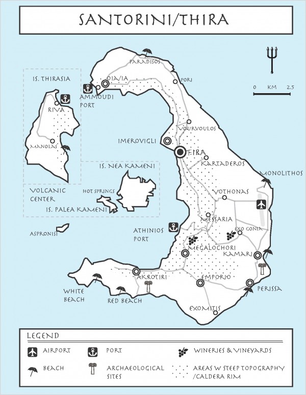
This article explores the vernacular architecture of Greece (in particular the island of Santorini), and also investigates such landscapes in times of economic debt & crisis. As the US government finally reaches a deal to end government shutdown and avoid default, we can look to other countries for precedents regarding how debt crises affect building, planning and constructed landscapes at the local level. This isn’t an alarmist cry against the certainty of a debt-ridden future. Instead, I tracethe possibilities of how debt affects the built environment, and ask if we should begin thinking about parallel models and case studies. Although Greece and its islands may comprise a much smaller geographic scale than the US or Canada, it is an instructive example and microcosm that we can learn from.
Greece. The word brings to mind a dazzling array of images. Whitewashed houses topped with cobalt blue roofs. Windmills and grape vines. Anthony Quinn dancing with a glass of ouzo by the sea. Yet what the word does not automatically trigger is desperate landscapes comprised of abandoned, half-constructed homes.
This article explores the vernacular architecture of Greece (in particular the island of Santorini), and also investigates such landscapes in times of economic debt & crisis. As the US government finally reaches a deal to end government shutdown and avoid default, we can look to other countries for precedents regarding how debt crises affect building, planning and constructed landscapes at the local level. This isn’t an alarmist cry against the certainty of a debt-ridden future. Instead, I tracethe possibilities of how debt affects the built environment, and ask if we should begin thinking about parallel models and case studies. Although Greece and its islands may comprise a much smaller geographic scale than the US or Canada, it is an instructive example and microcosm that we can learn from.
Greece’s ongoing debt crisis was triggered by the 2008 recession and resulted from a confluence of factors: 1) government deficit 2) government debt and 3) the structural weakness of the Greek economy. While the crisis drastically impacted Greek employment, tourism, and Euro exchange rates at the macroeconomic level, it also had a far more micro effect on Greeceat the local level. Examples of these incremental and parochial consequences come from the Greek Islands, where the effects of the recession are amply visible to the naked eye.

Half constructed house, Santorini. SOURCE: Nicola Szibbo, 2013
While driving and hiking around the Cyclades and the Dodecanese, one significant element in the fabric that I quickly noticedwas the striking amount of half-constructed buildings and homes (primarily residential building types). This was most apparent on the island of Santorini, readily apparent in the semi-rural areas removed from the tourist centers of the island. I found the contrast to be unsettling and raised important questions about urban and rural development on the island. How could so many buildings be left unfinished?

Imerovigli, Traditional Cave Vault Houses. SOURCE: Nicola Szibbo, 2013
Santorini, in particular, is known for its whitewashed roof vault construction. The particular building type is an important bioclimatic adaptation—the whitewash aids in the albedo effect, a passive cooling technique. The cave vaults also help keep the houses cool in the summer, as the earth dampens the diurnal and annual temperature fluctuations. In addition, such vaulted cave houses were often built into the earth around them, saving the need for extra materials and reducing space needs. The Cycladic islands naturally have scarcity of timber, although the island is blessed with an abundance of rich volcanic soil.
Source: Nicola Szibbo, 2013 (adapted from Frewin Poffley, 2013)
The island is crescent-shaped, and is actually an active volcano. Its volcanic nature is thought to have led to the demise of the Minoan civilization in Akrotiri at the south end of the island in mid-second millennium BCE. The island has often served as basis for the myth of Atlantis, as Plato recounts many similarities between the two places. The rich volcanic soil of the island has led to the harvesting of vegetables and fruit, in particular grapes for local assyrtiko and vinssanto wines, cherry tomatoes, fava beans and white eggplants. These local foods have become the foundation for the island’s popular gastronomic scene.

Unfinished house and/or commercial property. SOURCE: Nicola Szibbo, 2013

Half-constructed homes, Santorini. SOURCE: Nicola Szibbo, 2013
With its unique crater formation, the island has served as a mecca for tourism since the 1800s. Its natural viewsheds have created amphitheatric locations for towns such as Oia, Fira and its highest point, Venetian-settled Imerovigli. The rest of the island slopes down gradually from the caldera rim to the sea, and it is here on the eastern and southern ends of the island that you find an abundance of half-developed homes.
I asked our local guides, Yiannis and Paros, aboard a sailing trip that circumnavigated the island, why there were so many half-constructed homes (masonry and concrete structure present but lacking plaster or interior finishing). Paros answered that this was primarily a result of the economic recession—residents hadbegun the construction of homes, and then did not have the finances to finish them. Additionally, Paros mentioned that many of the partially finished buildings were illegal homes. Construction had stopped, as they did not have the requisite building permits from the government to continue. This also relates back to economic hardship, as proper permitting is often expensive and time-consuming.
Despite claims that Santorini managed to completely circumvent the negative effects of the recession, I remain unconvinced. How can one side of the island—the whitewashed rim with its vibrant architecture—look so profoundly magical, while the other seems desolate and abandoned? This was not the Greece I was expecting. The island had revealed a duplicitous nature—one side based on the bustling tourism industry, and the other suffering under the harsh, local reality prompted by the economic crisis.
Now, after 3 years of economic crisis, the Greek economy is beginning to stabilize. Whether or not some of these half-constructed buildings will be adaptively ‘re-used’ is a major question still to be answered. In a similar forlorn way, these abandoned, empty homes reminded me of the foreclosure crisis experienced here in the US. Is there a way to move forward with building from a sustainability standpoint? What can Greece learn from the foreclosure crisis in the US, and the US learn from the debt crisis in Greece?
Nicola Szibbo is a PhD candidate in the Department of City and Regional Planning at UC Berkeley. Her interests include vernacular architecture, green neighborhood rating systems and sustainable urban design in Europe, Canada & the United States. You can reach her at nszibbo@berkeley.edu.

World-Class Urbanism: A Glance at TEDCity2.0 and Place-making in the 21st Century
What defines the world-class city?
Who defines the world-class city?
These are the questions with which University of California Berkeley professor of City Planning Ananya Roy begins her headlining talk at TEDCity2.0. Roy takes the audience through an examination of the “cottage industry” of city officials, advocacy groups, and others who spend countless hours pondering this notion of world-class city identity. In municipalities across the globe, from Shenzhen, China, to Rio de Janeiro, Brazil, local leaders want to know whether they have the “it” factors for achieving world-class city status.

UC Berkeley Professor Ananya Roy. Source: TED Talks
Yet Roy argues that in the pursuit of becoming a world-class city, these leaders and their upper-class allies ignore and marginalize the very people who make the city successful. She notes that we frequently define the world-class city by physical markers such as having “spectacular architecture,” or being “always under construction.” Meanwhile, these cities are run by the cheap labor of workers we cannot see, and they begin to blandly resemble each other in their race to the forefront.
TED, which stands for Technology, Entertainment, Design, has been around since 1984, but has spawned a number of topic-specific events since then, such as TEDGlobal, TEDWomen, and of course, TEDCity itself. Aside from Roy, TEDCity2.0 features a number of notable speakers, including U.S. Secretary of Housing and Urban Development, Shaun Donovan, and Enrique Peñalosa, former Green Party mayor of Bogotá, Colombia. The conference’s impressive lineup of presenters and its focus on “re”making the city (the four sections of the event are entitled “Redefining Citizen,” “Reinventing Urban Experience,” “Reimagining the City,” and “Redrawing Geographies”) suggest that TEDCity2.0 is a small-scale reflection of the very same chase for world-class identity that Roy discusses in her speech. So does TED as a whole reproduce similar issues as world-class cities when it comes to structural marginalization?
Perhaps this is not how it has to be. In describing world-class cities, Roy tells us that we can redefine our conceptions of them through three different approaches: solidarity, visibility, and dwelling. In solidarity, we as consumers take some responsibility for the sources of our goods, as seen through examples such as the fair trade movement. If we have visibility, we pledge to see the urban poor majority as the dominant force in today’s city-making. And by dwelling, Roy means that we should challenge the development patterns of world-class cities, which benefit the rich and often involve displacement and undervaluing of the spaces inhabited by the poor. In these ways, Roy asserts that we can envision and create the City2.0 upon which the TED conference is based.
TEDCity2.0 is clearly reaching toward Roy’s vision, as the unspoken theme of the conference seems to be “re”discovering the city as human. For instance, after Roy’s remarks, peace activist Mohamed Ali tells us how a terrorist is born, by taking us into the perspective of a young rural migrant to Mogadishu, Somalia, and showing us the denial of opportunity he faces upon arrival. Later on, Kasim Reed, mayor of Atlanta, recounts the story of a long-time resident he meets while campaigning for office, and the lack of investment that makes her neighborhood one of the more challenging parts of city. Overall, TEDCity2.0’s speakers encourage us to connect in meaningful ways with others. And not simply the “others” that look like us. Maybe it is these stories that will lend us the inspiration and know-how to make the world class city more equitable.
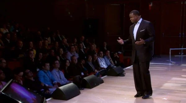
Atlanta Mayor Kasim Reed. Source: TED Talks
But there are also ways that TEDCity2.0 might not go far enough. Just as Roy describes how the invisible workers of today’s global cities need to become visible, perhaps the individuals who create TEDCity2.0 need to be seen in order for the event to reach its highest aspiration. This may mean anything from acknowledging and meeting the individuals who literally constructed the TEDCity2.0 stage to gaining a deeper history of the many people whose stories inspired the speakers that stand upon it.
There is a near-undeniable trendy and sexy feel to TED talks that makes us want to spread their messages to others through Twitter, Facebook, or Google+, yet it’s also important to ask ourselves what this really accomplishes. Is this true visibility and solidarity? While TED creates a fantastic space for exploring and deconstructing global cities, we must also think about the next steps. Otherwise, the event becomes the very epitome of what it analyses, a spectacle built upon the experiences of the underclass. If TED does alter how we think about the City2.0, the question we should ask ourselves is what exactly to do now with our new ways of seeing the world?
It’s precisely the answers to this final question that will define the next generation of planners, leaders, and activists. It’s the answers that will determine who we see at the next TEDCity event. But it will take time to see whether these are also the answers that will finally empower Roy’s urban majority to claim the numerous platforms that they have built throughout the world.
Stefani Cox is a master’s student in City and Regional Planning at UC Berkeley, where she studies community and economic development through the lens of equitable and participatory processes. She can be reached at stefanicox@berkeley.edu.
A New Mid-Market Street: Who is Left Behind?
All eyes seem to be on San Francisco’s Market Street these days. A long-stalled planning effort to redesign the street to improve conditions for transit, bicycling, and walking – dubbed the Better Market Street project – is at last progressing, with a final design concept being decided upon in the coming months. The many agencies involved in the project have struggled to create a unified vision for the corridor, since its character is so multifaceted and the street serves many competing roles. The backbone of San Francisco’s transportation network and its cultural center, Market Street is arguably the City’s most important street. Cutting diagonally from the waterfront on the edge of the Financial District all the way to the foot of Twin Peaks, Market Street is simultaneously a connector, a dividing line, and a place of its own.

Mid-Market has long been a place of concern – almost every Mayor in recent memory has made efforts to “clean up” the so-called blighted area. Directly adjacent to the Tenderloin and Civic Center neighborhoods, this middle section of Market Street is troubled by homelessness, drug addiction, prostitution, and other quality-of-life issues. On some blocks, almost half of storefronts are vacant and many buildings are falling into disrepair. Attempts to spark vitality by reviving the area’s roots as a theatre and arts district have only been somewhat effective. Now, the new concept is to reorient Mid-Market into a technology hub, which means remaking the area to attract newcomers, largely to the detriment of current residents.
In 2011, San Francisco officials enacted a package of loans, grants, and tax breaks to lure investors to Mid-Market. Though controversial, the plan seems to be producing results. Twitter’s arrival last year was the subject of most headlines, and other big technology firms like Dolby Labs and mobile-payment service Square have also recently moved into the area. But the allure is not just tax breaks – younger workers are increasingly forgoing life in the suburbs for a more lively urban experience. The advent of corporate shuttle buses carrying thousands of workers who live in the City to their jobs south of San Francisco each morning makes this point very clear. Tech firms are realizing this and are beginning to move the center of gravity from Silicon Valley to San Francisco, situating themselves where their employees want to live and work. Retail businesses are correspondingly turning-over, with expensive coffee shops, gourmet restaurants, and boutique chocolatiers taking their place. Change is afoot.
By early next year, the 754-unit luxury apartment complex NeMa (standing for “New Market”) will be complete, bringing thousands of new affluent residents to the area. A good number will work in the burgeoning tech industry. Mid-Market’s revitalization involves a very real change in the area’s identity, as the City caters to those who stand to bring the most capital into the area, with little attention given to the thousands who live on the streets and in low-rent housing. Just last month, police shut down an over 30-year tradition of Tenderloin residents playing chess on Market Street’s sidewalk – one of the corridor’s only visible images of community. SFPD Capt. Michael Redmond said the games had “turned into a big public nuisance” and he suspected they were “a disguise for some other things that are going on,” such as drug dealing and gambling. This once-forgotten stretch of Market Street is suddenly valuable, and the last thing the City wants to do is scare affluent people away.
What will all these changes ultimately mean for the neighborhood? Market Street will surely continue to be a place where people of all walks of life come together, but a process of harsh gentrification is nevertheless occurring. As Mid-Market reorients itself to be attractive for a younger and more affluent demographic, current lower-income residents are viewed as a nuisance – an expendable population tolerated only until renewal takes-off. San Francisco needs to reflect on the type of city it wants to be. As things are going, there will need to be a big change in perspective, unless it wants to relegate itself to being a playground for the rich.
Mark Dreger is working towards his Masters in City and Regional Planning at UC Berkeley, concentrating in transportation and urban design. He is a San Francisco native and interested in the nexus between systems of mobility and the public realm.
How to Stop the City of Berkeley’s Criminalization of the Homeless
One of the most popular pieces of advice to incoming students concerns walking around People’s Park and Shattuck Avenue, two of the most popular homeless encampment areas. While some claim that “no story of Berkeley is complete without the story of the homeless, whose presence has become familiar to residents,” many avoid these areas because they wish to avoid either the homeless themselves, their belongings (e.g. the sight and spread of their tattered blankets) or their companions (e.g. cats, dogs and other pets). Particularly on Shattuck Avenue, the downtown area where many local stores and restaurants are located, business owners express resentment, claiming that the homeless people have affected their daily operations. They have urged the city government to do something.
There have been recent attempts. The City of Berkeley proposed a controversial ballot measure to ban anyone from sitting or lying at the sidewalks during the day through Measure S, otherwise known as Civil Sidewalkers, in late November 2012. First-time violators would face a penalty of $75 or community service, while subsequent violations could be charged as misdemeanors. Measure S was voted down by a majority of Berkeley voters.
The message is clear: as the measure would have forbidden the basic activities of the homeless in commercial areas, it was really aimed at reducing the visible signs of homelessness. As advocates of the measure claimed, “living on the street is unhealthy, and sends people into a downward spiral” while “keeping shoppers away and hurting local merchants.” In their opinion, the assumed benefits of Measure S were to improve the quality of life of the homeless community by transferring them to the appropriate social services and to increase economic activity of local merchants in the area.
But how likely are policies such as Measure S able to accomplish what they are intended to? According to an article published by the Policy Advocacy Clinic at the UC Berkeley’s School of Law, “Will Berkeley’s ‘Measure S’ increase economic activity and improve services to homeless people,” the benefits are “neither proven nor promising.” Indeed, a similar sit/lie law, passed in San Francisco, was proved to be a failure. According to a recent report from the City Hall Fellows, the measure is radically ineffective in dissuading the city’s homeless from sitting on pavements, and it poses an extra cost to the police force, whose time could probably be better spent on inspecting other activities.
Although voters in a city that is no stranger to political movements said “no” to Measure S, Berkeley is far from having ended anti-homeless efforts by the city government. The victory for homeless rights advocates has proved extremely short-lived: Councilmember Jesse Arreguín has proposed a new series of actions to target the homeless community, dubbed the “Compassionate Sidewalks Plan.” The Compassionate Sidewalks Plan convenes a group of representatives to develop new regulations and law enforcement strategies based on consensus. But certain residents and community activists speculate that this plan is simply a masked version of Measure S, only this time more stakeholders—community members and government officials but not homeless people – are included in drafting a new measure.
Should the homeless be wiped off the streets of Berkeley simply because their appearance seems to deter shoppers and threaten the city’s image? At the very least, I believe, decisions about public space should not be weighted solely in favor of profit.
It is possible that the Compassionate Sidewalks measure would start a trend of criminalization and discrimination in Berkeley against those who are in need. The danger is that if any such measure was passed, the trend would officially be established, could be hard to terminate, and potentially lead to laws that further target homelessness and associated activities (e.g. cooking and congregating in public). Even if the policy successfully displaced the homeless community from the city’s surface, they will only migrate from one place to another, unseen from public view. In the absolute worst case, a sense of alienation is created among the needy, which further intensifies the ever-widening gap between the rich and the poor.
Compassionate Sidewalks is a thinly veiled attempt to hide homelessness, and it undermines efforts that could have addressed the true roots of the problem. Therefore, for incoming students, my alternative piece of advice would be to learn about the transient population first-hand instead of passively consuming formulated opinions about homelessness. A good start would be to volunteer with a student group like the Suitcase Clinic, or to visit People’s Park and Shattuck Avenue and talk to the homeless face to face instead of shying away uncritically.
Allista Cheung is an undergraduate student in Economics and City and Regional Planning at UC Berkeley. She can be reached at allista.cheung@gmail.com.
Third Nation or Trans-Nation? Remapping the US-Mexico Borderlands
Dear stakes his provocative assertion that the barrier will fail based on the historic and continued practices of transnationality (and economic interdependence) that undermine the wall’s claims of territorial national sovereignty. Drawing on borderlands historiography, Dear takes us back to the Comanches raids along the southern border prior to the U.S.-Mexican War (see Brian DeLay’s illuminating War of A Thousand Deserts) to suggest that the borderlands share more than a common history, but also blurred cultures, value systems, and practices of mutuality—in short, what Dear identifies as an alternative nationalism. Dear highlights the two dimensions that compose the “third nation’s” nationalism. Firstly the crossings, tunnels, economic interdependence, and other material exchanges that make up what Dear calls the “third nation before the wall,” and secondly, the cultural and language exchanges that make up what Dear calls the “third nation of the mind.” However, Dear for the most part engages these dynamics as parallel, rather than intersecting and inseparable. An illustration of this approach would be a focus on the ways that transnationality is experienced unevenly and unequally by borderlands residents, (for a rigorous analysis of the “nation form” see Manu Goswami, 2002).
Daniela De Leo, in her review of Dear’s book in Volume 26 of the Berkeley Planning Journal, questions the efficacy of a nationalism operating outside a formal nation-state. Perhaps this ambivalence comes from the lack of physical mediums through which nationalism can be performed and distributed in non-state spaces (Benedict Anderson’s famous example of the printing press in Western Europe comes to mind). I share De Leo’s concern. In the southern borderlands, these potential mediums are violently disrupted by physical and legal barriers—or more precisely, access to existing mediums is highly unequal. As geographer Doreen Massey would put it, “different social groups, and different individuals, are placed in very distinct ways in relation to these flows and interconnections.”
From the privileged perspective that comes with U.S. visibility, transnational fluidity seems remarkable. But from the perspective of Mexican citizens, physical transnationality can only be experienced after years of paperwork, steep fees, and too often, the risks involved with undocumented entry into the US. Similarly, cultural exchanges and economic interdependencies are highly uneven and often perpetuate inequality.
Alternatively, UC San Diego architect Teddy Cruz looks at borderlands through the lens of political economy, focusing on the vastly uneven experiences of transnationality along the border, resource flows, and the particular effects of borderlands capitalism. Instead of a coherent alternative nationalism, Cruz sees creative informality, which he argues, forces us to develop a new political language and spatial categories.
I do not suggest that alternative nationalisms can only emerge from state formations or that the “nation form” is an outdated frame, since nationalist movements from India to South Africa suggest otherwise. But in the US-Mexico borderlands, where the experience of transationality is highly uneven, I fail to see the usefulness in attributing territorial nationality to a place of informal dissonance, but exciting political creativity, as Cruz proposes.
Rather than a third nation, the southern borderlands lend themselves to an exciting alternative to bounded geographic models. Lucidly explained by Doreen Massey in her seminal essay, “A Global Sense of Place,” I want to suggest that we approach the southern borderlands not as a third bounded space carved out of a national boundary, but as a dynamic node of global interconnections where local histories, global capital, and uneven transnational agency come together in illumining ways.
Luis Flores is a 2013-14 visiting researcher at UC Berkeley under the auspice of the Judith Lee Stronach Baccalaureate Prize. His project, “Discovering the IRCA Generation” aims to produce a political economy of immigrants’ integration into housing markets during the 1990s and 2000s, illuminating the dangers of articulating assimilation with financial participation, as well as emphasizing the transnational dimensions to the Great Recession. Luis was raised along the southern border in the town of Calexico, California. He can be reached at jr.luisf@gmail.com
Dispatch from Dublin: Authenticity and Entrepreneurialism in the City of Saints and Scholars
Dublin is a city of juxtaposition. And perhaps city-ness is nothing more than a multiplicity of juxtaposition in form and function. But as it reimagines its past and rebrands its future as authentic, Dublin gives this truism some shape.
During our summer research with the Annenberg Scholars Program in Culture and Communication and the National University of Ireland Maynooth, we grappled with the prevailing forces shaping Dublin’s realities. In particular, we reckoned with what David Harvey identified as an emergent but dominant mode of urban governance: entrepreneurialism [1]. The city as enterprise. The city as facilitator and partner. The city as both place and place-maker. What was the relationship between “the political economy of place and the cultural politics of place” [2]?How did the contingencies of Dublin – the city and the city-brand – and Ireland – the nation and the national imaginary – shape the city government’s entrepreneurial endeavors?
Attending the Dublin City Council's StartUp City charrette, we began to see how the city's ongoing transformations and internal tensions were etched into the built environment. The event, in which teams variously comprised of city officials, urban designers, hackers, and entrepreneurs presented proposals for improving city support for small to medium-sized enterprises, was located in the City Council's Wood Quay offices along the River Liffey. Once there, we found ourselves in the City Wall Room, an immense conference space in the office building's basement, named for the Viking-built wall undergoing archaeological excavation at the time of the site’s construction – the wall that lay dormant behind the speakers, their Prezis, their future-motifs. Not only were Dublin’s deep past (as Viking settlement) and immediate future (as an entrepreneurial e-city) juxtaposed in this ethnographic moment, so too were the specters of its more recent history – a history of vast public campaigns to halt construction, a history of voices extinguished, of democracy, public space, and urban identity in doubt.
One StartUp City team focused on encouraging street markets by streamlining the bureaucracy for establishing new hubs. While officials and developers see these hubs as catalysts for entrepreneurship, urban livability, and local investment, commitment to existing markets was waning. The sites of extant locales have increasingly become targets for large-scale development projects that cater to the ongoing hope for middle-class influx.
Hopping between these market hubs, we saw an abundance of forms, styles, and purposes: from the sidewalk vendors in the Liberties selling cell phones, toilet paper, toys, batteries, and watches, angry with the City Council for doubling their stall fees; to the Temple Bar Food Market and Cow’s Lane Designer Market, where gourmet fare is hocked upscale tourists and locals and is carefully managed by the city’s Temple Bar Cultural Trust; and the Ballymun Farmer’s Market, inside a new but failed shopping mall in a northern suburb dominated by social housing.
In a subtle yet striking juxtaposition, two types of markets emerged after the Celtic Tiger crash: sprawling, outer-city car boot sales and curated, inner-city flea markets. In poorer suburbs, car boot sales attract hundreds of vendors and thousands of visitors. Furnishings, appliances, toys, and jewelry sell for a couple of Euros. Vendors pay a small fee to set up shop, their wares laid out on a table or blanket as they chat with friends nearby, bargain with shoppers, or peruse cars arrayed in rows, face-to-face, boot open. Vendors are usually under- or unemployed, and the sale is only one of their many informal trades.
Meanwhile, the inner-city’s flea markets cater to a younger, hipper crowd, selling homemade and vintage jewelry, vinyls, antique furniture, old fashionable clothing, and art. A founder of the Dublin Flea believes that this new interest in markets is partly a shedding of the middle-class fear of being associated with peasant culture. City Council representative Siobhan Maher, on the other hand, imagines it a tourism amenity: “visiting people want to find the quirky stuff.” Perhaps the street market presents a variety of opportunities for what Sharon Zukin calls “shopping for authenticity” [3]: a few extra dollars for vendors and for the government, a way to encourage individual entrepreneurship at a low risk, and a way to validate authenticity through consumption.
But authenticity can be an elusive siren. And the quest for it dictates much of urban governmental action. Cities seeking to foster authentic built environments and a creative material personality must make concessions; the role of government must be transformed. The City Council, wary of its own preponderance, strives to become a facilitator of authentic creativity and urban place-making.
Channels are thus created for the sourcing of citizen input at the front-end of development. The Studio, an “interdisciplinary” branch of City Council founded after the economic crisis, looks for “new ways to engage with the public that are less formal [and] less officious.” The hyper-localized urban connaissance of what it means to be a resident of Dublin, on x street in y neighborhood, becomes the currency of city officials. New rituals and frameworks for public engagement are enacted. The Dublin City Beta Project transforms the city into a “test-bed” for seemingly radical, citizen-sourced design concepts to improve street life. Citizens become users of the city-as-product, and the entrepreneurial city knows what its users want.
The Digital Dublin Master Plan and Dublin City Public Realm Strategy each project an image of perfected, open city-ness, in which consumers of city-space provide constant input to the City Council in real time, a feedback effect that risks being construed as a substitute for democracy. These newly-minted initiatives are aspects of an explicit imperative to “open” the city – to make big data available, open source, for developers and citizens. The open city extends beyond the digital and into the public realm, where clever “hacks” of public space are now praised and promoted by city officials. Reports like these are mechanisms of power, not because they shape the future, but because they coordinate “a shared belief in the future” in the present [4].
In Dublin, city of juxtaposition, these techniques call attention to themselves. Public spaces are no longer the physical and social domain of the commons but “a key part of the city’s identity and distinctive character [whose] quality affects the city’s competitiveness and ability to attract investment.” Smart, open, transparent, walkable, consumable cities. The imperative is to spatialize a city-image attractive to consumers of urban authenticity. What comes into relief, however, is not a city trying to improve the conditions within its territory, but an enterprise with the singular objective of competing with its global peers in attracting capital.
Aaron Shapiro and Emily Ladue are doctoral students at the Annenberg School for Communication at the University of Pennsylvania. Aaron studies cities, intellectual technologies of urban revitalization, and commodity aesthetics. In particular, he is interested in urban design and planning as spatial techniques of government. He can be contacted at ashapiro@asc.upenn.edu. Emily is studying urban development, dispossession, and consumption in US cities. She is also a filmmaker looking to express this research through video projects. Her email is eladue@asc.upenn.edu.
Leveraging Large Scale Development for Equity and Sustainability?

The Oakland waterfront redevelopment project called Oak to Ninth is back in the news after Governor Brown and Mayor Quan recently secured $1.5 billion in funding from a Chinese investment company. The Oakland’s City Council approved the project and a Community Benefits Agreement (CBA) in 2006, but the developer, Signature Properties, never broke ground due to the recession. In 2011, city officials even tried (and failed) to attract the planned satellite campus of Lawrence Berkeley National Laboratory to the site. Now, the development is proceeding with a new name: Brooklyn Basin.
Like fees and exactions, CBAs represent a developer’s contribution to the local community as a condition of receiving public subsidies and permits. Going beyond baseline payments for infrastructure such as roads and schools, CBA campaigns can target affordable housing and workforce development, among other local needs. They can involve diverse stakeholders, as well as more immediate input from the public than fees and exactions, which may be assessed automatically.
Oak to Ninth put equity advocates and the developer in an unlikely alliance. Once the City and the developer had signed a development agreement that included community benefits and enforcement provisions, community groups came out to planning meetings to support the project. This placed them at odds with environmentalists, intent on maintaining an earlier agreement with the city that created a greater amount of public open space from the former industrial site, as well as historic preservationists who wanted the whole Ninth Street Terminal, not part of it, restored.
Site of Brooklyn Basin, the project formerly known as Oak to Ninth (Google, Europa Technologies, TerraMetrics 2007)
Today, Plan Bay Area and other efforts to promote smart growth in the region suggest that environmental and social justice groups are much less at odds with each other. This is partly due to a greater aligning of goals between environmental groups and organizations focused on social justice and community development. The former have focused their agenda more on urban issues, in addition to wildlife preservation outside cities. The latter have focused on health and opportunities in the green economy. Both have come together around the uneven impacts of climate change.
With Oak to Ninth-Brooklyn Basin and its accompanying CBA looking set to move forward again, it’s worth checking in with the overall concept of community benefits. In the time that Oak to Ninth lay dormant, CBAs were tested, shown to have some fundamental weaknesses, and improved upon. The foreclosure crisis and a new drive to link sustainability with housing and land use under Plan Bay Area provide a different backdrop for the project than the pre-recession real estate market did.
At 30 acres, Brooklyn Basin is small compared to other large-scale infill projects such as the Railyards in Sacramento (240 acres), the future terminus of California’s high-speed rail line, or the Brooklyn Navy Yards in New York (300 acres). Yet Brooklyn Basin will be significant for reconnecting Oakland neighborhoods south of Downtown with the waterfront. The site borders Chinatown, Lower San Antonio, and Fruitvale, where there are high poverty rates and a need for jobs and affordable housing.

Brooklyn Basin plaN (Signature Properties 2013, http://www.brooklynbasin.com/images/sitemap.jpg)
In the seven years since the Oak to Ninth project approval and CBA campaign, Oakland has experienced high foreclosure rates, rising unemployment, and social movements targeting income and housing inequality, such as Occupy Oakland. Developer funding for job training programs and affordable housing stalled along with the Oak to Ninth project. However, as soon as the first building permit is issued on the multi-year project, $1 million will be divided among several Oakland job-training programs, with another $325,000 specifically for job training in Chinatown, Fruitvale and Lower San Antonio. In terms of housing, 465 affordable units will be built onsite-- about 17 percent of a total 2,765 units.
Oak to Ninth was approved at a time when CBAs were becoming a popular tool for equity advocates. CBAs provide a political rallying point for sharing the benefits of publicly funded projects, rather than simply halting them. The Staples Center CBA (2001) is considered an early model for community groups to negotiate for first source hiring, living wage, and affordable housing when large public subsidies for development are at stake. Yet CBAs can also reflect broader power imbalances. Who represents the “community” can come up for debate, as it did with the Atlantic Yards CBA (2005).
The Oak to Ninth CBA was grassroots-driven. A group of labor, neighborhood, faith-based and equity advocates were among the coalition members who created political pressure for the City of Oakland to approve the development agreement that codifies the CBA. The City of Oakland, eager to attract development, was a reluctant partner in the CBA, but eventually signed a development agreement that is binding for both the City and the developer. Among the agreement’s safeguards are payroll reporting by contractors and financial penalties if targets are not met.
The local hiring provisions of the CBA are designed to help Oakland workers without significant previous experience break into the construction trades. It does this by requiring that six percent of the job hours on individual parcels be carried out by Oakland residents who are new to the construction trade, with an incentive to keep the same workers on the job for the equivalent of 23 full time weeks. Although this is only a small percentage of the site hours, the effect will be that at least a third of the apprenticeships – paid, entry level, career path positions - on each project site will be filled by Oakland residents.
CBAs have become more common since Oak to Ninth, and with more examples have come lessons for their proponents. Enforcement mechanisms are key, and the most effective CBAs provide a stepping-stone to stronger citywide policies on local hiring and affordable housing, rather than project-by-project funding. Although a more comprehensive citywide policy on community benefits has not materialized in Oakland, members of the Oak to Ninth CBA coalition have put the experience they gained to use. In 2012, EBASE helped negotiate a stronger CBA in connection to the redevelopment of the Oakland Army Base. The site will remain industrial, creating construction as well as long term living wage shipping and logistics jobs for Oakland residents and residents of the high unemployment area of West Oakland.
The loss of state funding has complicated local redevelopment, but public funding and permitting of large-scale development remains a leverage point for equity and sustainability advocates. As it moves forward, the Brooklyn Basin project will provide much-needed local investment, but work remains to be done to make housing and employment more equitable in Oakland and in the Bay Area across the board.
Lizzy Mattiuzzi is a doctoral candidate in City and Regional Planning at UC Berkeley. She studies the politics of sustainable land use, transportation, and community development at the urban and metropolitan scales. She can be reached at emattiuzzi@berkeley.edu.
From Project to Pre-Fab: A Window into Future Affordable Housing
Affordable housing in the United States echoes a continuously changing ideology of the most effective, safe, and desirable way to house the poorest and most marginalized people of our society. In the 1960s, the idea was that affordable housing had to first and foremost accommodate immense numbers of people. Subsequent massive projects such as Pruitt-Igoe in St. Louis and Cabrini-Green in Chicago were constructed. It was later realized that such poorly designed and enormous publicly run housing projects led to widespread crime and danger. During the next phase, affordable housing was built on a much smaller scale, managed by private developers, and not segregated from more well-off neighborhoods. While this type of lower density housing harbors a much more hospitable environment, it cannot accommodate the growing number of poor Americans.
The most recent question surrounding affordable housing is how to construct quality, well-managed, safe, publically funded housing for the poor in the mass quantities that are needed to make a dent in homelessness.
The Skid Row Housing Trust (SRHT), based in Downtown Los Angeles, has attempted to tackle this question. Skid Row is an area in downtown Los Angeles that contains the highest concentration of homeless people in the United States. Streets are lined with cardboard, shopping carts, tents, and belongings. SRHT strives to assist the 3,000-6,000 people living on these streets by constructing affordable and desirable housing. The Star Apartments, the first pre-fabricated affordable housing complex, are an effort to construct a larger scale, well-designed project at minimal cost and construction time. The Star Apartments will cost $20.5 million and will consist of 102 units built in a factory and then stacked on site in just over a month. According to the Los Angeles Times, the project, designed by renowned architect Michael Maltzan, will include basketball courts, art centers, community gardens and green space. Star Apartments will serve the entire Skid Row community through services and public spaces. Residents will pay 30% of their income and will not be mandated to attend any counseling or social services. The Skid Row Housing Trust advocates for the so-called “housing first” model, which argues that the most effective way to deal with homelessness is to provide sustainable housing as quickly as possible, regardless of the level of stability of the resident.
Due to this unconventional model, Star Apartments have been the subject of controversy. Residents of the Star Apartments do not have to prove that they are on “the right path,” because “housing first” prescribes that once homeless people have housing, improvement and stability will follow. Opponents, such as conservative radio talk show host John Carlson, call such projects “bunks for drunks” and argue that in order to make a real difference in homelessness, residents need to be mandated to stop “risky behavior” and take proactive steps to better their life.
The Journal of the American Medical Association (JAMA) conducted a study to evaluate the effectiveness of “housing first” programs in reducing chronic homelessness and health care costs. Costs of individuals living in housing first programs were compared with those on the waitlist for the same type of housing but who were still living on the streets. Including housing expenses, public service costs decreased from $4066 to $2449 per person per month after a twelve-month period. This study thus demonstrates that it is actually cheaper to provide subsidized permanent housing for the chronic homeless than to pay for public health and safety services. Give the homeless homes, and the reduction of drug use is secondary to the numerous benefits that come with safe, sanitary, and sustainable shelter.
Critics of the Star Apartments might also take issue with the relatively low capacity of the project. However, regardless of its size, this well-designed building has the potential to completely change an entire community. A mixed-use housing project provides the space for people of the whole neighborhood to collaborate and build relationships. While it may house fewer people than a Cabrini-Green or a Pruitt-Igoe, it has the potential to positively affect the lives of many more.
In addition, others might claim that though the project will attempt to nurture a safe environment, it is still located on 6th and Maple; residents will still live in the heart of Skid Row and it will be nearly impossible to escape its lifestyle. But to argue that a project should be built in a different region is to completely give up on Skid Row and settle that it will never be a productive or family-conducive community.
In order to understand why it is important that Star Apartments is located in Skid Row, it is necessary to understand the dynamics of the area. In the documentary Lost Angels: Skid Row is My Home, director Thomas Q. Napper, attempts to justly frame the Skid Row community and the issues it faces. The documentary demonstrates that even though crime and drugs are rampant, the region has also nurtured a unique, lasting sense of community. Kevin “KK” Cohen, who is profiled in the film, lived on Skid Row for 14 years and became the fiancée and protector of Lee Anne Leven, an older, mentally ill, hunched-over Skid Row native. KK claims: “I would defend her with my life, believe that, dude. I would die behind this little lady right here.” Skid Row has fostered this unique and compelling relationship. I believe that while it is important not to isolate the poor from urban life, it is just as essential that longstanding neighborhoods are not abandoned because of negative outsider conceptions.
The Star Apartments could be the model for the future of affordable housing. However, as Mike Alviderez, the Executive Director of the Skid Row Housing Trust, told the L.A. Times, “We’re not going to be able to build our way out of homelessness.” Pre-fab affordable housing must not be seen as a solution for homelessness but as a way for those who are desperately poor to begin to climb out of poverty. It is one step in the mitigation of homelessness, just as pre-fab affordable housing can be viewed as one phase in the United States affordable housing timeline.
Hannah Squier is a second year Civil and Environmental Engineering major at UC Berkeley. She is interested in the way engineering and urban planning intersect to solve social and systemic injustices. Feel free to contact her at hannahsquier@berkeley.edu.
Beijing Homeless
Things change when there is no place to go. A city loses itself when the gravitational force on metros, buses and people loses its hold. Before opting out, I was living in a nice place, working for a good office, and spending time with close friends. From the apartment at Sihui Station to the office on Tuanjihue Lu; from the diplomatic areas of Dongzhimen to the alley bars of Gulou, work life and personal life revolved around design scenes, family-style meals, and group outings. This is how I interacted with the city, and this is how the city interacted with me. But once these things, these places, and these people were gone, Beijing became something less familiar.
Maybe I had watched Into the Wild one too many times. Maybe I thought I was a character in a Knut Hamsun novel. Or maybe it was that I had experienced a broken heart. But as my lease at the Gemdale Plaza next to Line 1 came to an end, I filled a backpack, dropped my luggage off at a friend’s house, and spent the next 8 months looking for the best places for personal displacement. I didn’t know where I was headed, or if being headed anywhere made much sense. All I wanted was nowhere, and I wanted it wherever I could find it.
Beijing is a cold city in more ways than one. The winter of 2012 was no exception. The wide-open spaces created an impersonal landscape of gray brick and white barriers. Low-density blocks the size of airport runways made my jacket feel thinner, as exhalation would come to obstruct my vision. Within these vast openings would sometimes sit a bench, isolated and prominent, as if drawing attention to itself just by existing. I began to find comfort in the outskirts. I would seek out the corners and retreat into the narrowness. The hutongs were mazes, and mazes are indeed fun when time is irrelevant. Once, I would get frustrated when I ended up in the wrong side street to meet friends at an obscure pool hall. Now, my frustration applied itself to a stopping point.
Physical movement became more necessary as the temperature ticked downward. I sometimes found myself on the periphery, running in place, waiting for 10am, when the nearest heated space, known as a shopping mall, would open its doors. To me, malls were giant mixed-use monstrosities, and I found myself in them more often than not, resting, reading, and writing. The couches were more comfortable than the concrete, and the clean bathroom stalls made napping manageable. Laowài were welcome there, and I took full advantage.
I even spent a few nights in the biggest, freest hotel in Beijing: Foster’s Capital Airport.
I spent little time in parks with their controlled access points and more time under overpasses, as they felt freer and at the same time more private. When the ring roads intersected a highway, the massive looping exits created pockets and barricades. Businesses operated along the roads running underneath the 8-lane traffic several meters above. Medians were brick islands with a width of two lanes. Where the overhead’s giant concrete columns touched down on these islands, a good place for leaning was born. Nearby, tunnels could be found that gave pedestrians and cyclists a means of punching through the vehicular onslaught. It is within these negative spaces that city equipment was stored and traces of graffiti could be discerned. Beyond the sound of revving engines and blaring horns, it was a place of burnt wood and loneliness. Sometimes, I would find jackets and blankets, a pile of flattened cardboard boxes, a lighter, a cup. And no one else.
In order to bypass the roads, the highways, and the noise that accompanied them, I would sometimes travel the city canals and walk for miles and miles. Like the tunnels and grooves, I felt safe and off-the-grid, with the benefit of a de-saturated sky above me. I went to places I had never been, and I spent time in places that I had once enjoyed with the people that I used to know. It was at this old sky bridge where a pointless conversation had taken place, a time of eye contact, winter jackets, and the backsides of green traffic signs. But my memories were fading, and it became harder to figure out what was so special about that damn sky bridge.
By the spring, I was no longer serving drinks and cleaning bathrooms in exchange for a bed at the local hostel. I had removed myself from the couches of generous friends. I had left my new job of only 3 months, and the convenience of their office furniture. My nights were now spent on patches of grass between sidewalks and tower plinths. Long-haired and bearded, I continued walking the city, often without an idea of where I was. Beijing is not known for way-finding, so I followed whatever way I could find. I would hike along railroad tracks, watching vendors sell clothing, books, and chuanr. They never noticed me, and I never minded. The city was now blooming, and the large setbacks became small green parks with foliage-draped benches and places for locals to nap and water the flowers. It barely rained, and when it did, I found the nearest awning, metro station, or mall. I was now used to it all.
By the fall, I had made it into Mumbai, India with a void work visa. My distaste for Beijing was at an all-time high. I had championed Beijing the previous year, only to become too intimate with its reality as compared with my own. Everything I had loved about the city was associated with and based upon everything I had now lost. Through my own stupidity, I had broken, ruined, and separated myself from every personal and professional association that I had obtained while living in the city as an architect. Now the city was lacking because I myself was lacking.
Beijing became a barren wasteland, and my understanding of cities had changed. A city can be many things: It can be clean. It can be dirty. It can be pleasant or stressful. It can have a public transportation system and a logical road network or be lost within chaos. It can feel as if home, or it can resemble something foreign. But without the stability of relationship, a point of contact, with a person, a job, a bed, the reference is lost, the meaning is void. Without this framework, the city bleeds away into empty materials and emptier buildings, an ocean of grayscale pavement, broken up by stoic park benches. Things change when we have no place to go. Or we have no place to go because things change. Either way, as Steven Wright once said: Anywhere is walking distance if you’ve got the time.
Brad Hooks is an architect who graduated from the Savannah College of Art and Design. He has worked for ATOL Architects in Shanghai, URBANUS Architecture & Design in Beijing, and Studio Mumbai Architects in Alibag, among others. He now lives and works in Ahmedabad, India. You can reach him at brad.hooks@gmail.com.
Transformative Love & Conditions of the Concrete: A Reflection on the Martin/Zimmerman Verdict
From the violence experienced by youth, to the imbedded racial discrimination experienced by people of color in the trial court system, to the obsession of the construction of whiteness around Zimmerman who in the end killed a young innocent man—there are so many powers at play in this case, and so many things to say. But I want to focus on what themes have been springing out from the dreadful case that are connecting to the work I seek to do with my own experience as a planner in training, but also as a woman of color deeply involved and in youth organizing, environmental and restorative justice, and community. The Missing Link of Transformative Love
Some of the people that I look to when working as a planner and as a community member are my sisters and guides whose wisdom I access through books: the radical feminists of color, in particular Professor of English and activist bell hooks who posted a response. In her acclaimed book, All About Love, hooks writes:
“The growing number of gated communities in our nation is but one example of the obsession with safety… The person who is really the threat here is the home owner who has been so well socialized by the thinking of white supremacy, of capitalism, of patriarchy that he can no longer respond rationally.
White supremacy has taught him that all people of color are threats irrespective of their behavior. Capitalism has taught him that, at all costs, his property can and must be protected. Patriarchy has taught him that his masculinity has to be proved by the willingness to conquer fear through aggression; that it would be unmanly to ask questions before taking action. Mass media then brings us the news of this in a newspeak manner that sounds almost jocular and celebratory, as though no tragedy has happened, as though the sacrifice of a young life was necessary to uphold property values and white patriarchal honor…. This is what the worship of death looks like.”
This excerpt alone could have been a response to the Trayvon Martin case outcome where hooks describes how youth, particularly young men of color, are seen as a threat. Unlawful and devoid of humanity through their criminalization, young men of color are then subject to the racialized systemic violence and discrimination due to deeply ingrained societal racism. She also links the environment in which we live, the social and concrete ecosystem of place and space that make up the violence and the social understanding of what it means to be black and dangerous.
Her response to this phenomenon is that of transformative love, how the power of love can transform communities, socially and physically. Some people look at the matter of love as something of a subjective nature, something that is not objective. Similarly, some might underestimate this blog piece and deem it as a mere social science theory. But as a planner, I have to look at its application in the real world. Transformative love to me is not as theoretical as it seems; in fact, it can only be reached through simple and practical applications such as engaging in real conversations with each other.
The reason Trayvon Martin died is because we, as a society, do not communicate. We need to invest in one another. One group’s equality must be invested in another group in order for us to move forward to better cities, better schools and a better environment. I believe our society can no longer afford to leave some groups struggling, while others enjoy economic, social and physical protection. As hooks explains in her last sentences, justice itself is wrapped up in the love of human dignity. I think this is something that we have lost as the Trayvon Martin Case/Zimmerman acquittal becomes more and debated and sensationalized.
Trayvon’s life may have been like any other urban kid’s experience. Surrounded by poverty and stricken by lack of opportunity, young people like Trayvon Martin are harassed and need to defend themselves. These conditions often result in the murder of such young men. Trayvon Martin’s murder is the loss of a life, but it is also the loss of an opportunity for the entire world to see what young people like Trayvon can offer. What worldly perspectives, what deep insight on poverty, resilience, love, dedication, problem-solving and ingenuity can the strong and creative minds of our youth offer? And, most importantly, at what rate and at what cost are we losing them, especially our youth of color?
Roses from Concrete: What Makes Up the Concrete
Another idea that has been circulating the blogosphere and social media outlets has been that of Brooklyn-based black feminist scholar and activist Syreeta McFadden: “Only in America can a young black boy have to go to trial for his own death.” Not only can a black boy go to trial after his death, but it is only after he dies that his life is recognized as a life—or that his life can make it to the big screen. From Rodney King to Oscar Grant—America is familiar to stories like these. However, what about other deaths in our neighborhoods, the deaths of the urban poor?
I ask these questions because it is clear that black and brown bodies are not only unsafe in white spaces, but that the very spaces where poor people of color have grown up and that they have sustained are terrorized with hyper police-reinforcement, low health outcomes, and very little opportunity for educational success. These questions are part of the death sentence killing youth of color and they are also part of the work that comes with the privilege to plan cities. However, these are also the questions that have very little room in planning classrooms or in commission meetings.
Lastly, let us not mistake the murder of Trayvon Martin as an act of an individual; rather it was an entire system that killed Trayvon. As many of us mourn this loss, I think of the families of fallen heroes, of these roses from concrete. However, this cannot paralyze us. Let us honor the lives of these young people by actively creating avenues for transformational love that can change the way cities function and the way historically marginalized people live. Let us create new planning approaches, so that their environments and life outcomes can match the dignity of their lives.
Mar Vélez is a master’s student in both the Department of City and Regional Planning and School of Public Health at UC Berkeley. She is currently interning with the Pacific Institute and working along side Communities United for Restorative Youth Justice (CURYJ) in Oakland on issues of health, gentrification, gang injunctions and popular education methods for participatory planning strategies for sustainable communities. Yes, all these things are related. She can explain how if you reach her at velemar@gmail.com.
Planning for Equity and Racial Tolerance: Reflections from a White Planner on the Zimmerman Verdict
It seems clear that what can be called casual racism had a significant role in this case. What made Zimmerman think Martin (and the several other African American men he reported to the police) didn’t belong? What assumptions made at least one juror think these suspicions were justified? Why would the police at the scene test the dead black teenager for drugs, but not his killer? Would each of these people have responded differently if Martin had been white? I can’t help but think that the answer is at least “probably” if not “yes.”
These questions have also made me consider how racial bias and white privilege has played out in my own life, and in the work that I do as a planner. I grew up in a mostly white, upper-middle class suburb in California, partly in a townhouse development that looked not too different from Retreat at Twin Lakes, where Martin was staying and where he was killed. While overt racism was not tolerated, subtle biases were rampant. The town rejected new public transit investments and tore down one of the few affordable housing options (a trailer park) to replace it with condos in order to keep low-income people out. I remember being told as a kid that I had to do better in school, or else we would move to East Oakland. At a young age, I learned that white people and white places were at the top of a certain hierarchy, and that others did not belong. I imagine Zimmerman was acting based on similar assumptions.
The research on implicit bias has shown that nearly all of us carry racial assumptions, oftentimes at a subconscious level that we don’t realize or want to admit to. But the consequences of these biases are real and can be deadly, particularly against black men and boys like Martin who are stereotyped in our society as dangerous.
Planning tools are not neutral – they interact with these implicit biases and racial stereotypes, more often than not to keep low-income, African American, and other communities of color separate and unequal from white communities. Single-use zoning and efforts to stop affordable housing developments have been used to keep low-income families (and oftentimes people of color) out of neighborhoods. Non-white renters and home buyers still face well-documented discrimination by both real estate agents and lenders when looking for a home. People of color are shown less home options, and poorer quality options, than their white counterparts. And they are much more likely to end up with a subprime loan, even when they qualified for better terms.
The discrimination may no longer be codified in deeds, but the impacts are clearly visible. Schools are as segregated today as they were 50 years ago, with African American and Latino students overwhelmingly attending low-performing schools in high poverty neighborhoods. But the way I learned this as a kid was that bad students (of color) from East Oakland went to bad schools, as if somehow the students themselves were to blame.
As planners – and especially white planners from the ‘burbs like me – we need to recognize our own implicit biases and think critically about how these assumptions may play out in our work. We need to speak up on issues of equity and inclusion in our cities and towns. We need to recognize when coded racial language is being used (like claims that affordable housing will increase crime rates, or calls for more local control) and engage city staff, electeds, and residents in constructive conversations about race, privilege, and community planning. We need to conduct equity analyses of city plans and policies to identify any negative impacts on low-income communities and communities of color, and ensure these impacts are addressed proactively.
We also need to address these issues at the structural level, creating policies that support inclusion and racial equity. Recent initiatives to promote regional planning, like Sustainable Communities, can help create more integrated and diverse communities that begin to unravel the stereotypes and create better opportunities. We need to disrupt the school-to-prison pipeline and provide education and workforce training tied to career opportunities so that all residents can succeed, regardless of where they live. And we need to recognize that demographics in this nation are shifting rapidly, with people of color already the majority in many states and regions. Our suburbs in particular are becoming more diverse, and we need to put strong community development infrastructure in place to support them.
We owe it to Trayvon Martin and countless others to create more equitable communities that promote racial tolerance, not feed into racial fears. For many of us, that work has to begin with an honest look inward at our own biases and assumptions.
Chris Schildt, MCP ’12, is a program associate at PolicyLink, a national research and action institute advancing economic and social equity, based in Oakland. She conducts research on equitable economic growth strategies, including best practices for advancing equity in job creation, entrepreneurship, and workforce development. She can be reached at cschildt@policylink.org.
Eyes on the Street: CED Alum’s Film Finds an Audience
While a graduate student at the College of Environmental Design, Darryl Jones completed the short film This Is Market Street as a companion piece to his thesis in landscape architecture. The film, shot in 2012, spurs a dialogue about the future of Market Street, San Francisco’s most central street, and preserves an experience of the corridor before its transformation. This Is Market Street is screening for free at the San Francisco Public Library at 6:00pm on Wednesday, June 26, and at SPUR at 12:30pm on July 11. A panel discussion and Q+A will follow. Presented by Walk San Francisco and the Better Market Street project. For more information, go to http://www.walksf.org.
Why did you make this film? Why Market Street? Why a film?
I have been a hobby filmmaker since I was kid, but the landscape has always been my inspiration. I saw this as an opportunity to merge two of my interests: landscape architecture and filmmaking. For the past few years I have been thinking about how to do it, and it dawned on me that graduate school would be a good place to start. In fact, during a conference at UC Berkeley in the early 2000s, a group of landscape architects deliberated on the idea of how film could be utilized to bring the landscape, and landscape architecture, into the cultural mainstream. Reading about their discussions inspired me to answer their call.
I chose Market Street in San Francisco because currently, there is a huge effort to study and eventually redesign the street. It intrigued me because it is a monumental design project, not the kind you see very often, and I knew it would be happening for several years, so hopefully, the film would have some traction. Also, it is my hope that my film will be an educational artifact, long after the street has changed.
How was making the film? How much time did you spend filming? How much time did you spend on Market Street?
The key to good film production is good pre-production, which I didn´t really do, I’m a little shy to admit. Like I said before, I grew up making films, but I learned how amateur I was as a result of this project. This realization has actually led me to pursue more of these projects. The historical footage is all from a website called www.archive.org, and if you haven´t used it, it is a great resource, even if you´re just curious about history! Some of the footage is from the Prelinger Archives, a Library of Congress collection, which is curated by Rick Prelinger, a Bay Area archivist and writer. He has compiled some amazing collections of archival footage of San Francisco and the Bay Area, including A Trip Down Market Street, which is the infamous film taken from the top of a streetcar on Market Street only days before the 1906 earthquake.
All in all, I spent 14 days shooting and usually was on Market Street an average of two-three hours each day. I complied 55 interviews, almost all of which are in the film. As is typical of documentary filmmaking, I discovered, it really comes together in the editing room. I spent probably triple the time editing than I did actually shooting on Market Street.
Why do you think will Market Street be redesigned and how will it be?
It’s still a little early in the process, and the Better Market Street team isn’t quite in the unique design phase yet. They have presented three options and are at the stage of getting feedback on those options. Part of the purpose of these screenings on June 26 and July 11 is to raise awareness about the upcoming public workshops, where everyone can go to be a part of the decision-making.
Personally, I think San Francisco is ready for a more pedestrian Market Street. That is the key to it becoming more livable, because it’s just a ghost town in some places, and unsafe in others. Since Market Street is so integral to all the other modes of transit and the flow of adjacent streets and spaces, it is going to take some bold experimentation and inspiring proposals to actualize this project.
How do you feel about Market Street?
That’s a tough question. I think Market Street inspires me. It feels like the center of the city, and I believe that is a really important feeling for a city to have. Feeling like you’re at the heart of it all is one of the best feelings about cities; when you say to yourself "I’m really here right now—this is where the energy is". It’s no mistake that tourists come to Market Street. Obviously, they come for the cable cars a lot of the time, but I think they really come to experience the heart of the city. There is something monumental about its size and orientation that cannot be denied, and when you revisit history, you start to really root for Market Street.
Is the redesigning process on Market Street similar to what is happening in other cities?
I’m not sure I can answer that accurately, but from my experience I have definitely seen these projects in other cities. My hometown of Raleigh, North Carolina, redesigned their two main streets in recent years, to much success. However, cities are always making plans to revitalize their streets, so it’s nothing new. But the scale of what is being proposed for Market Street may be very ambitious compared to other cities.
Do you think your film will make a difference?
I certainly hope so! If anything, I just hope it will encourage people to be excited about how design affects their lives, and that they can be a part of the conversation.
Is it home? [Watch the film to understand the significance of this question!].
Haha, good question. For me, truthfully, it isn’t. I live in Oakland, so that may be why. But I certainly feel a connection with Market Street, and the more time goes by, the more it becomes familiar to me and the more I admire it.
Darryl Jones is a recent graduate of the University of California, Berkeley, where he received his Masters of Landscape Architecture. He is an active artist, designer and filmmaker whose work focuses on the relationship between people and their environment, specifically as a human being on foot. He currently works at a small architecture practice in San Francisco, CA. Darryl can be reached at DarrylJones@cal.berkeley.edu.