
The Battle of Baxter Creek: Resolving Power Struggles in a Community Green Space
This is a tale of a well-intentioned stream restoration project in a residential park-neighborhood of Richmond, CA that sparked a community power struggle. The unintended consequences of the restoration left the neighborhood divided. Neighbors who wanted to reduce criminal activity in the park were pitted against those attempting to promote local pride with aesthetic improvements. It provides an interesting case study bothfor understandingsuccessful urban creek restoration and neighborhood-level politics.

This is a tale of a well-intentioned stream restoration project in a residential park-neighborhood of Richmond, CA that sparked a community power struggle. The unintended consequences of the restoration left the neighborhood divided. Neighbors who wanted to reduce criminal activity in the park were pitted against those attempting to promote local pride with aesthetic improvements. It provides an interesting case study bothfor understandingsuccessful urban creek restoration and neighborhood-level politics.
Booker T. Anderson Jr. Park is a family-oriented green space serving a neighborhood located in Richmond, CA -- a city with high levels of crime. Beginning in the year 2000, an unappealing, blighted, channelized stream crossed the park that separated the park’s community center from a playground, soccer and baseball fields. Lisa Owen Viani, then graduate student at UC Berkeley, developed a project to transform this eyesore to a riparian green space, including a lush thicket of native willows based on regional heritage.
However, as time passed, the design’s obstructed sight-lines resulted in unintended public safety issues. One incident involved a police chase of an armed individual who fled into the understory of the willow thicket as kids were playing in the nearby playground and fields. This situation created a heightened fear of the willows among residents and park users. It also alerted the police to this area as a potential zone forcriminal conduct. Residents also reported increased muggings and drug and sexual activity in the area since the landscape project was implemented.
In the summer of 2007, while the director of the Parks Department was on leave, department staff responded to an outpouring of complaints by commissioning a “city maintenance crew who’d clear-cut everything below about five feet,” according to the Berkeley Daily Planet, which dubbed it the Richmond “Chainsaw Massacre.” While this resulted in improved sight lines that addressed the safety concerns of both the neighborhood and police department, some residents believed this to be a misallocation of limited resources that diminished the positive effects of the restoration.
It is important to understand how this community power play surrounding the stream restoration evolved. The seeds of this battle were sown over a decade ago when Lisa Owens Viani gathered support from a consortium of citizens, scientists, government and non-government agencies, including the Urban Creeks Council (UCC) and the City of Richmond. The UCC and the Friends of Baxter Creek received $150,000 to restore the storm drain to a ‘natural’ creek with riparian vegetation. At the time, typical restoration practice was placed-based. This method restores habitat to an historic state that once existed, from which plant and wildlife succession would follow naturally. Historically in the Bay area, many low-elevation streams were dense with thickets of willows. Using this method, the creek became a thriving ‘natural’ area that benefitted the ecosystem and the neighborhood, as well as providing a sense of identity among organizations from multiple local, regional, and state community interests.
In the ensuing years, the willows began to dominate the urban stream and the project soon became problematic for the community. The dense thicket of trees was no longer perceived as a safe place for children to play along the banks of the creek to catch tadpolesand butterflies. Several public meetings were held during the initial development; however, not all interested parties felt that the city had given them an accurate portrayal of how dense the thicket would become, a factor that contribute to the concerns of both the neighborhood and police department.
In reality, the 2007 “Chainsaw massacre” only destroyed eight willows out of several hundred on the project site, while the remaining trees were merely trimmed to allow for protective sight lines. But, after the uproar, a stakeholders’ meeting was quickly organized by the leader of the original project, Lisa Owens Viani, and supporter Ann Riley, a well-known stream restorationist and staff member of the Water Board. At that meeting, City Council member Tom Butt said that some members of the community desired ‘natural’ growth while others favored surveillance-ready spaces. He pointed to a gap in communication between planners and neighborhood stakeholders such as the local Neighborhood Watch group. This lack of communication ultimately prevented all of the stakeholders from coming to an agreement as to what defined a desirable park.

After the dust settled on Baxter Creek, valuable lessons emerged for planners, restorationists, and the surrounding neighborhood. The traditional historical ‘place-based’ method of restoration is not always the best for a given community. The sociological environment of the neighboring community is a key element in a successful restoration project. Tailoring the project to the needs of the neighborhood is as important as selecting the type of plants and wildlife to returning a creek to an enduring and healthy state. In addition, a plan needs to account for the maintenance of the restoration over time.

As it turned out, the City responded by funding $60,000 to further investigate neighborhood concerns, supplement the willows with a flowering chaparral understory (a novel approach in contrast to traditional riparian planning), and maintain four safety sight lines between the community center, playgrounds, soccer and baseball fields. The UCC immediately began their outreach to residents, which included door-to-door and mail surveys, along with four community meetings held over the course of a year. In 2008, an agreement was reached to construct a written management plan that would address the interests of all stakeholders, any change in maintenance crew protocols, and turnover among governing bodies. Since then the rancor from the Baxter Creek power struggle has subsided. Good landscape projects require prudent planning. From this experience, future landscape designers can take-away valuable lessons about the need to tailor restorations to a given community and ensure that they will be maintained over time.
Ken Schwab is an undergraduate of the University of California, Berkeley, where he is majoring in Conservation and Resources Studies at the College of Natural Resources. He is currently working an honors thesis, funded by SPUR and mentored by Dr. Vincent Resh, on the longest post-project monitoring of a ‘daylighted’ urban stream which includes: community perception, biological and habitat assessments, and a pioneering economic evaluation. He is actively involved with the Strawberry Creek Restoration, with Dr. Katharine Suding, which received a grant from The Green Initiative Fund (TGIF) -- Fitting Plant to Place: Site-Specific Restoration Planning on Strawberry Creek. Ken can be reached at ken.schwab@berkeley.edu.

Vestiges of San Francisco’s Unbuilt Waterfront
San Francisco has oftenserved as a blank canvas since its rapid rise to prominence after the Gold Rush in the mid-1800s – the subject of countless visions for how the built environment should be designed. Whilesomewereoutlandish and others more grounded, the many ideas advanced over the years for guiding the City’s development have each presented a roadmap for moving forward, complete with nested values of what is most important for the future. Such is the subject ofUnbuilt San Francisco – an exhibit currently presented at five locations around the Bay Area, including at UC Berkeley (more details below). On display are plans, renderings, models, and other media depicting unrealized visions for the San Francisco Bay Area. Some of these proposals, such as a BART line running into Marin County, many wish had been built; others, like Marincello, a 30,000-person community in the now-preserved Marin Headlands, we cannot imagine advancing today. The exhibit covers a journey of great breadth, ultimately leaving the viewer with anuneasy sense of what could have been.
San Francisco has oftenserved as a blank canvas since its rapid rise to prominence after the Gold Rush in the mid-1800s – the subject of countless visions for how the built environment should be designed. Whilesomewereoutlandish and others more grounded, the many ideas advanced over the years for guiding the City’s development have each presented a roadmap for moving forward, complete with nested values of what is most important for the future. Such is the subject ofUnbuilt San Francisco – an exhibit currently presented at five locations around the Bay Area, including at UC Berkeley (more details below). On display are plans, renderings, models, and other media depicting unrealized visions for the San Francisco Bay Area. Some of these proposals, such as a BART line running into Marin County, many wish had been built; others, like Marincello, a 30,000-person community in the now-preserved Marin Headlands, we cannot imagine advancing today. The exhibit covers a journey of great breadth, ultimately leaving the viewer with anuneasy sense of what could have been.

In the 1960s, a large planned development was proposed to be built in the Marin Headlands by the Gulf Oil Corporation. In the face of strong opposition from various environmental groups, in 1972, the company reluctantly sold the land so it could be incorporated into a new national park – the Golden Gate National Recreation Area. Source: Thomas Frouge, developer
The lasting impact of the Unbuilt San Francisco exhibition, though, is not simply an understanding of the Bay Area’s various unrealized futures, but more fundamentally an appreciation of how the choices made in the past impact how we see things today.
San Francisco’s ever-evolving waterfront is an excellent case study. Indeed, the edge of the Bay might have turned out quite differently than what we see today. A turn-of-the-century plan imagined the Ferry Building at the foot of Market Street surrounded by towering Roman-style columns. Decades later, another would have replaced San Francisco’s beloved waterfront monument with a modernist-inspired World Trade Center, surrounding a large sun dial. These ideas may sound outlandish today, but they were seriously considered at the time.
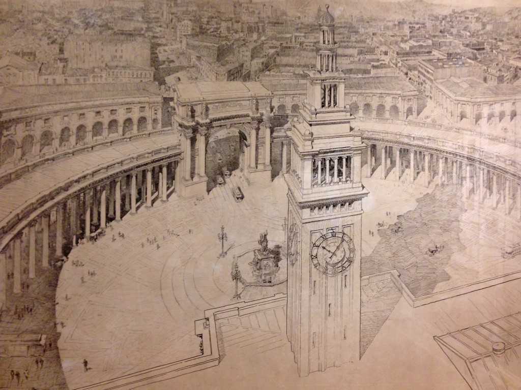
This turn-of-the-century vision would have created a grand public space in front of the Ferry Building encircled by classically-styled columns and arches. Source: Willis Polk (1897)

Another vision would have done away with the Ferry Building altogether and replaced it with a modern World Trade Center. The slender center tower and sun dial seem to allude to the structures they would have replaced. Source: Joseph H. Clark (1951).
One idea in particular has had an enduring influence on how we envision the waterfront today: the proposal for an elevated high-speed motorway running the length of the Bay’s shoreline.
In the 1950s, following the national trend, an ambitious network of limited-access freeways was conceived for San Francisco, crisscrossing all corners of the 7-by-7-mile city. Despite being swept up by the freedoms of automobility, freeways were far from welcomed in San Francisco. As the first few structures went up, including the double-decker Embarcadero rising between Market Street and the Ferry Building, people began to realize the damaging effects the roads were having. In swift response, the now famous Freeway Revolt was born.

Citizens crowd into City Hall wearing signs on their heads to express their opposition to the freeways being erected all over San Francisco. Source: San Francisco History Center, San Francisco Public Library.
Freeways in San Francisco were opposed for various reasons, but much of the discourse centered on aesthetics and access. Beyond being unsightly, neighborhoods that received the early motorways were walled off from their surroundings and quickly succumbed to blight and loss of vitality. After years of fierce opposition, the citizens' revolt was ultimately successful in blocking most proposed freeways, and the Embarcadero was only partly completed (it was originally proposed to connect with the Golden Gate Bridge). Just 21 years after the Embarcadero’s completion, it took only seconds for the 1989 Loma Prieta earthquake to damage the structure enough to warrant taking it down. Though many enjoyed the access it provided and called for reconstruction, then-Mayor Art Agnos envisioned a new aesthetically-pleasing waterfront, and fought for the freeway to be replaced with the grand boulevard we know today. Few look back longingly.

Citizens crowd into City Hall wearing signs on their heads to express their opposition to the freeways being erected all over San Francisco. Source: San Francisco History Center, San Francisco Public Library.
The unrealized vision for a complete freeway network in San Francisco has left citizens sensitized not only to future roadway proposals, but also to any project that might possibly impact the waterfront’s aesthetics, access, or views. One need look no further than the controversial 8 Washington project rejected by voters earlier this month – what would have been a 134-unit luxury condominium development along the waterfront, adjacent to where the Embarcadero Freeway used to stand – to see this. The project had diverse opposition – from those who questioned building $5 million condos in a city struggling to provide affordable housing,to those who criticized its parking ratios – but most discourse concerned appearance and accessibility. Critics focused on the project's 13-story height, roughly twice that of the late freeway, claiming it would have blocked views and access to the Bay, thereby tarnishing the waterfront’s appeal.

This rendering, drawn up by supporters of 8 Washington, takes an elevated perspective, showing the tall buildings of the Financial District in the background, to downplay the project’s heights.
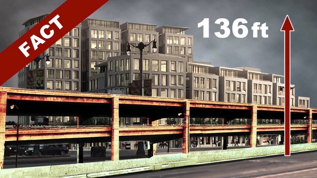
The opposition's image instead takes a ground-level perspective, juxtaposing the Embarcadero Freeway in front of 8 Washington, to illustrate the development’s towering design.
In typical San Francisco fashion, the 8 Washington debate became so heated that it was the subject of not one but two propositions on the November ballot earlier this month. Voters were asked if they approved of the decision to allow the project to exceed existing height limits. The ‘No on B & C’ campaign strategically employed the slogan “No Wall on the Waterfront” and made direct comparisons to the Embarcadero Freeway (campaign ad embedded below). Former Mayor Art Agnos reemerged as a spokesperson for the opposition, proclaiming that “8 Washington will be the first brick in a new wall along the waterfront.” Despite the obvious differences between the fallen freeway and 8 Washington, people were concerned that the progress made along the waterfront in recent years would be lost if the proposal moved forward. Ultimately, both initiatives were soundly voted down almost two-to-one. The developer may choose to return with a new down-sized proposal, but at least this version of 8 Washington joins the list of San Francisco’s unrealized visions.
http://www.youtube.com/watch?v=cujWdElxCHk#action=share
Ideas remain unrealized for many reasons – because they do not match prevailing values, they were not well-conceived, or perhaps they just were not well-articulated – but some nevertheless persist, influencing decision-making to this day. The many unbuilt visions for San Francisco’s waterfront have not only influenced what was actually built, but have left a more enduring impact on how people imagine its possible futures. Turning over the waterfront to the purely utilitarian role of moving automobiles was ultimately rejected, replaced by a more aesthetically-focused public space. The discourse surrounding this unbuilt vision continues, sensitizing people to anything that might once again “wall off” the Bay’s shoreline. Planners and designers would be smart to inform themselves of the waterfront’s complex evolution, lest they propose something that has no chance of actually being built.
Unbuilt San Francisco is a collaborative effort of AIA San Francisco, Center for Architecture + Design, Environmental Design Archives at UC Berkeley, California Historical Society, San Francisco Public Library, and SPUR. The exhibition will be on display at various locations throughout the Bay Area through the end of November 2013. More information about specific dates and locations of showings can be found on the organizational websites linked above.
Mark Dreger is working towards his Masters in City and Regional Planning at UC Berkeley, concentrating in transportation and urban design. He is a San Francisco native and interested in the nexus between systems of mobility and the public realm. He can be reached at m.dreger@berkeley.edu.
How to Stop the City of Berkeley’s Criminalization of the Homeless

One of the most popular pieces of advice to incoming students concerns walking around People’s Park and Shattuck Avenue, two of the most popular homeless encampment areas. While some claim that “no story of Berkeley is complete without the story of the homeless, whose presence has become familiar to residents,” many avoid these areas because they wish to avoid either the homeless themselves, their belongings (e.g. the sight and spread of their tattered blankets) or their companions (e.g. cats, dogs and other pets). Particularly on Shattuck Avenue, the downtown area where many local stores and restaurants are located, business owners express resentment, claiming that the homeless people have affected their daily operations. They have urged the city government to do something.
There have been recent attempts. The City of Berkeley proposed a controversial ballot measure to ban anyone from sitting or lying at the sidewalks during the day through Measure S, otherwise known as Civil Sidewalkers, in late November 2012. First-time violators would face a penalty of $75 or community service, while subsequent violations could be charged as misdemeanors. Measure S was voted down by a majority of Berkeley voters.
The message is clear: as the measure would have forbidden the basic activities of the homeless in commercial areas, it was really aimed at reducing the visible signs of homelessness. As advocates of the measure claimed, “living on the street is unhealthy, and sends people into a downward spiral” while “keeping shoppers away and hurting local merchants.” In their opinion, the assumed benefits of Measure S were to improve the quality of life of the homeless community by transferring them to the appropriate social services and to increase economic activity of local merchants in the area.
But how likely are policies such as Measure S able to accomplish what they are intended to? According to an article published by the Policy Advocacy Clinic at the UC Berkeley’s School of Law, “Will Berkeley’s ‘Measure S’ increase economic activity and improve services to homeless people,” the benefits are “neither proven nor promising.” Indeed, a similar sit/lie law, passed in San Francisco, was proved to be a failure. According to a recent report from the City Hall Fellows, the measure is radically ineffective in dissuading the city’s homeless from sitting on pavements, and it poses an extra cost to the police force, whose time could probably be better spent on inspecting other activities.
Although voters in a city that is no stranger to political movements said “no” to Measure S, Berkeley is far from having ended anti-homeless efforts by the city government. The victory for homeless rights advocates has proved extremely short-lived: Councilmember Jesse Arreguín has proposed a new series of actions to target the homeless community, dubbed the “Compassionate Sidewalks Plan.” The Compassionate Sidewalks Plan convenes a group of representatives to develop new regulations and law enforcement strategies based on consensus. But certain residents and community activists speculate that this plan is simply a masked version of Measure S, only this time more stakeholders—community members and government officials but not homeless people – are included in drafting a new measure.
Should the homeless be wiped off the streets of Berkeley simply because their appearance seems to deter shoppers and threaten the city’s image? At the very least, I believe, decisions about public space should not be weighted solely in favor of profit.
It is possible that the Compassionate Sidewalks measure would start a trend of criminalization and discrimination in Berkeley against those who are in need. The danger is that if any such measure was passed, the trend would officially be established, could be hard to terminate, and potentially lead to laws that further target homelessness and associated activities (e.g. cooking and congregating in public). Even if the policy successfully displaced the homeless community from the city’s surface, they will only migrate from one place to another, unseen from public view. In the absolute worst case, a sense of alienation is created among the needy, which further intensifies the ever-widening gap between the rich and the poor.
Compassionate Sidewalks is a thinly veiled attempt to hide homelessness, and it undermines efforts that could have addressed the true roots of the problem. Therefore, for incoming students, my alternative piece of advice would be to learn about the transient population first-hand instead of passively consuming formulated opinions about homelessness. A good start would be to volunteer with a student group like the Suitcase Clinic, or to visit People’s Park and Shattuck Avenue and talk to the homeless face to face instead of shying away uncritically.
Allista Cheung is an undergraduate student in Economics and City and Regional Planning at UC Berkeley. She can be reached at allista.cheung@gmail.com.